Showing posts with label Landslide. Show all posts

Friday, October 28, 2016

News in Japan - October

USA

Other
Watersheds Lost Up to 22% of Their Forests in 14 Years. Here’s How it Affects Your Water Supply High erosion deteriorates water quality and reduces reservoir capacity, increasing the cost of water treatment and the risk of contamination. High erosion risk is usually linked to erodible soil, intense rainfall, steep topography and conversion of forest and other natural lands to pasture, cropland and more.
How fast will we need to adapt to climate change? Using sea-level rise as a case study, researchers at Carnegie's Department of Global Ecology have developed a quantitative model that considers different rates of sea-level rise, in addition to economic factors, and shows how consideration of rates of change affect optimal adaptation strategies. If the sea level will rise slowly, it could still make sense to build near the shoreline, but if the sea level is going to rise quickly, then a buffer zone along the shoreline might make more sense. "It is a very different thing to adapt to a sea level that is three feet higher if you think that sea level will rise no farther after that, than to adapt to a sea-level rise that is three feet higher with the expectation that the seas will keep rising," remarked Soheil Shayegh, a former Carnegie postdoc and lead author of the study.
Reservoirs play substantial role in global warming The world's reservoirs are an underappreciated source of greenhouse gases, producing the equivalent of roughly 1 gigaton of carbon dioxide a year, or 1.3 percent of all greenhouse gases produced by humans.
Evaluating forecasting models for predicting rainfall from tropical cyclones more than 50 percent of the deaths associated with hurricanes from 1970 to 2004 were caused by fresh water flooding. And from 1981 to 2011, hurricane damage accounted for almost half -- $417.9 billion -- of the total monetary damage from all weather and climate disasters during that same time period (adjusted for inflation to 2011 dollars). Current models can forecast both where and how much rainfall a tropical cyclone will produce up to two days in advance. However, the forecast's accuracy decreased significantly when the prediction window increased to five days.
Hurricane Matthew is just the latest unnatural disaster to strike Haiti At least 1,000 people were killed when Hurricane Matthew battered the Tiburon peninsula in Haiti last week, destroying houses and displacing tens of thousands. Other experts describe disasters as “manifestations of unresolved development problems”. Therefore, disasters are not a natural phenomenon. Humans play a central role. As a result, a natural hazard such as Hurricane Matthew impacts each country in its path differently. We know that development, imposed by external forces that exploit the local labour force is not in the interest of the marginalised. A failure to respect human rights, local needs, the environment and human-environment relations simply creates disaster risk.
Scientists find link between tropical storms and decline of river deltas Lead researcher Professor Stephen Darby of the University of Southampton said: “Our study is the first to show the significant role tropical storms play in delivering sediment to large river deltas.  We show that although human impacts affect the amount of sediment in a river – cyclonic activity is also a very important contributing factor. These results are very significant because the Mekong’s sediment load is already declining as a result of upstream damming and other human impacts such as sand mining. Understanding the role played by changes in tropical cyclone climatology gives us a broader knowledge of the threats facing this delta and others like it around the world.” 
Receding glaciers in Bolivia leave communities at risk  A new study published in The Cryosphere, an European Geosciences Union journal, has found that Bolivian glaciers shrunk by 43% between 1986 and 2014, and will continue to diminish if temperatures in the region continue to increase. "On top of that, glacier recession is leaving lakes that could burst and wash away villages or infrastructure downstream," says lead-author Simon Cook, a lecturer at the Manchester Metropolitan University in the UK.

Friday, May 27, 2016

News in Japan - May

Japan:
80% of SDF big choppers couldn’t fly for Kumamoto mainly because they were undergoing emergency checks
Gov't to call for beefing up support for foreign visitors in disaster (Japan) Tourism organizations should get the picture of the locations of evacuation centers as well as hospitals that can accept foreigners, according to the planned request. The guidelines state examples of foreign language terms regarding evacuation and advice, and urge making use of volunteer interpreters and preparation of emergency meals that can be provided to Muslims.

Friday, April 29, 2016

News in Japan - April

GEJET:
Court dismisses demand to halt Sendai reactors A Japanese high court has dismissed a request by residents to suspend operations of 2 nuclear reactors at the Sendai nuclear plant in southwestern Japan. The Miyazaki branch of the Fukuoka High Court gave its decision on Wednesday.

USA:
5 Dead in Houston as Flash Floods Leave Thousands Stranded and Without Power All five victims were found inside vehicles submerged in high floodwaters. “Houston residents should avoid travel at all costs today.”
Disaster plans often neglect historic preservation (USA) In Florida, for instance, they found that 23% of the sites listed on the National Register of Historic Places are located in a 100-year floodplain. Most communities have not integrated historic preservation into their disaster management plans. Their survey of state hazard mitigation plans found just 40 percent included a representative from historic preservation on the core planning team while 60 percent did not. "Many disaster mitigation plans make no mention of historic resources," Rumbach said. "As more and more communities bank on historic resources to benefit the local economy, this needs to be remedied." Economics aside, he said, many communities draw a sense of identity from these historic sites and can become unmoored when they are damaged or destroyed.

Netherlands:
Dutch public works department reinforces coastline at Zandvoort (Dutch) 2.4 million cubic meters of sand are being applied to the coast of Zandvoort and Bloemendaal. This previously happened in 2004 and 2008. The sand is deposited 750 meters from the beach at a depth of five meters. Wind, waves and currents then gradually spread the sand towards the beach. The work takes place over a length of 7.5 kilometers along the coastline, without disrupting beach visitors.
Snow in North of Netherlands and Randstad (Dutch) including fierce hail storms, leading to serious traffic accidents.

Tuesday, April 19, 2016

Earthquake in South Japan - part 3: Landslides

A first analysis of the landslides East of Kumamoto city have become available. The photos are courtesy of Kokusai Kogyo Co., Ltd. (国際航業株), taken on 16 April 2016; the maps are freely available from the Japanese GSI. These maps and photos show the earthquake damage points of concern (平成28年熊本地震災害で懸念される地震被害箇所), with a focus on river blocking by collapsed hill sides (河岸崩壊による河道閉塞箇所).

Affected area #1 lies between Kumamoto city and Mount Aso (阿蘇), just west of Kawayo (河陽), on Bungo highway (国道57号線).

You can also view the before/after photos in a google earth type environment here, courtesy of the GSI. More pictures, videos and maps here. See also the 3D model of area #1 and this drone video of area #1.

Friday, October 30, 2015

News in Japan - October

GEJET:
TEPCO rejected requests for anti-tsunami steps before nuclear crisis
First cancer case confirmed from Fukushima cleanup

Japan:
Behind the Scenes / Concern for privacy of Joso missing excessive
Volunteers mucking in to help Japan clean-up

USA:
Hurricane Patricia Recap: Strongest Landfalling Pacific Hurricane on Record
Flood risk on rise for New York City, New Jersey coast, study finds
One-two punch of rising seas, bigger storms may greatly magnify US East coast floods

Netherlands:
Pop-up Exhibition in Dordrecht on potential flood disasters

Other:
In dryland African regions, limiting wildlife water access can reduce water quality
NASA studying 2015 El Nino event as never before
Want To Know How Sea Level Rise Will Impact Your Hometown? There’s A Map For That
Surging seas mapping progress
Researchers work on model to help restoration managers with decision-making (USA, Germany)
Why some scientists are worried about a surprisingly cold ‘blob’ in the North Atlantic Ocean
Work starts on Sendai indicators

Vulnerable People:
Japan’s child poverty above OECD average
Shibuya Ward to begin accepting applications for 'same-sex partnership certificates'

Japanese flood and landslides:
Here are the latest statistics from the Japanese government's Fire and Disaster Management Agency and other national and local governments as of Friday, Sept. 18:
•        The death toll is eight: three in Tochigi Prefecture, three in Ibaraki Prefecture, and two in Miyagi Prefecture.
•        There are 46 confirmed injuries, with Ibaraki Prefecture accounting for 24 of them.
•        A total of 18,882 dwellings have been confirmed flooded. Ibaraki leads this list as well, with 12,088 flooded homes.
•        In addition to the flooded homes, 16 dwellings have been destroyed and another 102 have structural damage.
•        Damage also occurred to 61 non-residential structures.
•        Damage to the agricultural, forestry and fishing industries has reached 11.7 billion yen (about 98 million U.S. dollars).
•        At least 455 landslides were reported – 358 of them in Tochigi Prefecture alone, and 312 of those in the city of Nikkō, according to the prefectural government.
•        Up to 26 inches of rain fell in eastern Japan Sunday through Friday due to Tropical Storm Etau and its remnant low.
•        Local officials in Ibaraki Prefecture said 1,344 people had been rescued via helicopter by the country's Self-Defence Force and rescuers from 10 of the country's 47 prefectures.
Key developments in the storm:
•        On Wednesday, Sept. 16, officials confimed the death of a 40-year-old man who had been out on his bicycle when the floods hit Ibaraki Prefecture on Sept. 10.
•        A 60-year-old man was found dead Saturday after the vehicle he was in was swept into a flooded river Friday morning in the city of Kurihara, Miyagi Prefecture. A 48-year-old woman also died in that incident.
•        Japanese media said a pair of eight-year-old boys were among those found alive and removed from the list of missing Saturday.
•        Two men, ages 71 and 51, were found dead in rice fields flooded by the levee breach in Joso, according to public broadcaster NHK. The men were not previously among the list of missing.
•        The Japanese government's Fire and Disaster Management Agency confirmed that a man found dead in a flooded vehicle in Tochigi Prefecture Sunday morning died of storm-related causes.
•        A 63-year-old woman was confirmed dead after a landslide struck Kanuma city, Tochigi Prefecture, early Thursday. The woman was missing for hours before being found dead Thursday evening.
•        A man in his 20s was confirmed dead Friday after falling into a flooded drainage pipe Thursday in Nikkō city, Tochigi Prefecture.
•        Rare emergency weather warnings were issued for Tochigi, Ibaraki and Miyagi prefectures on Thursday and Friday, but have all since been lowered.
•        A magnitude-5.2 earthquake struck Tokyo Bay at 5:49 a.m. local time Saturday, rattling the entire Tokyo region and prompting fears of quake-triggered landslides in rain-soaked hilly terrain.
•        The earthquake injured seven people in Tokyo and its suburbs, according to the FDMA.
•        Another earthquake, rated magnitude 4.6 and centered off the east coast of Ibaraki Prefecture, rattled the Joso flood zone nearly six hours later but with weaker ground shaking.
•        The Shibui River broke through a levee in Ōsaki city, Miyagi Prefecture, on Friday morning. At least 1,000 people were stranded in floodwaters, according to the newspaper Asahi Shimbun.
•        The Japan Meteorological Agency issued the maximum "Level 5" flood warning Friday for the Yoshida River in Miyagi Prefecture and for the Mogamiogumi River in Yamagata Prefecture.
•        More than 800 people in the mountainous town of Minamiaizu, Fukushima Prefecture, were cut off from the outside world due to flooding and landslides on the lone highway through town Friday.
The Japan Meteorological Agency issued a rare emergency heavy rainfall warning for Miyagi Prefecture and its 2.3 million residents early Friday as torrential rains continued to drench the prefecture, which includes the city of Sendai, raising concerns of landslides and river flooding. The JMA observation site near Sendai's central business district reported 269 millimeters (10.59 inches) of rain in the 24-hour period between 7:40 a.m. Thursday and 7:40 a.m. Friday local time. (Japan is 13 hours ahead of U.S. Eastern Daylight Time.) JMA lowered the warning for Miyagi Friday evening.
"We can say this is an abnormal situation and there is imminent serious danger," said Takuya Deshimaru, chief forecaster at the Japan Meteorological Agency, according to the BBC.
On Thursday, JMA issued similar emergency weather warnings for 5 million people in Tochigi Prefecture and Ibaraki Prefecture, north and northeast of Tokyo, on Thursday morning. The warnings were issued as a band of heavy rainfall associated with the post-tropical remnant of Tropical Storm Etau stalled over eastern Japan, dumping up to 21 inches of rain in 24 hours near the head of the Kunigawa River, which drains south through the northern suburbs of Tokyo.
The emergency warnings in Tochigi and Ibaraki prefectures were lowered Friday morning.

Thursday, October 8, 2015

Population preparedness in Europe

September's edition of Crisis Response featured an article on the disaster preparedness of the population in France, Belgium, UK, Portugal, the Netherlands, Greece). It proved what was generally known: people are mostly unprepared and expect the government to come save them.


Read more on how the study recommends to use social media to gather and distribute accurate disaster information at the Crisis Response journal. 

Sunday, April 12, 2015

7th WWF day 1

7th World Water Forum in Daegu and Gyeongju, Korea - day 1

Today was the first day of the world water forum. We joined the opening ceremony on Daegu, at the exhibition center called EXCO. As it was quite crowded, there was a special room for VIP members to view the ceremony live, and another room for additional visitors to watch it on screens. In total, the secretariat reports there were over 3,000 people attending the opening ceremony. Security was heavy as President Park of Korea and many other heads of state were present in the building. As in Japan, Korea likes the use of mascots and we were treated abundantly with examples of traditional clothing, dances, sports, and many other cultural aspects.

Monday, March 16, 2015

WCDRR day 3

World Conference on Disaster Risk Reduction in Sendai - day 3

In the middle of this conference I was able to visit 5 events on this day. The first was a technical session on the methods used in the Global Assessment Report 2015 at Tohoku university. The second and third took place at the International Center and covered financial aspects of disaster risk reduction. Another session there covered land use planning, while the last, at Tohoku university, was a very special session about the formation of a Delta Alliance, initiated by the Dutch government and attended by one of the Dutch princesses. 

Sunday, March 15, 2015

WCDRR day 2

World Conference on Disaster Risk Reduction in Sendai - day 2

Today I visited 4 sessions, the first three at the Sendai international conference building and the last at Tohoku University, located on a beautiful hill side, at Hagi hall (presentations will follow). The hagi tree is the symbol of the university.
My main question during the presentation of the Global Assessment Report 2015 was how the work of the GAR differs from ICHARM's goal to make a risk index. The main points include ICHARM's focus on flood hazards, end point indicators of governance and resilience of communities, and the national level and cooperation with national governments in creating and applying the index data.

Saturday, March 14, 2015

WCDRR day 1

World Conference on Disaster Risk Reduction in Sendai - day 1

Arriving in Sendai today, I only had time to visit two sessions after registration.The first session was held in the main conference building and concerned the Hyogo Framework for Action priority 2 where ICHARM member Sawano-san was a panel member; the second was a symposium held across town in the AEX tower where GRIPS students presented their finding. Below are the lessons learned from these sessions.

Friday, November 28, 2014

News in Japan - November

GEJET:
All spent fuel removed from Fukushima Daiichi No. 4 unit pool
TEPCO unable to stop tainted water flows into tunnels

Japan:
Snow-capped Mt. Ontake still spewing smoke, ash
Nishinoshima eruption one year on Japan Coast Guard officials say that as of October 16th, the island measured 1,550 meters east to west and 1,700 meters north to south. That is 8.6 times larger than it was before.
Hakuba ski resorts quell rumors of quake damage
The magnitude 6.7 quake, which hit a little after 10 p.m. on Saturday night local time, left dozens of people injured, seven of them seriously. Public broadcaster NHK reported that over 300 people are still living in evacuation shelters as of Tuesday morning. According to the Geospatial Information Authority of Japan, Hakuba slipped southeast towards Tokyo by approximately 29 centimeters (about one foot) due to the quake. The city also sank by around 12 centimeters. The quake's epicenter was about five kilometers (three miles) underground near Hakuba. The area has since been hit by multiple aftershocks, including one Tuesday morning that had a magnitude of 4.1.

Netherlands:
World Bank wants the Netherlands to play a more prominent role in addressing global water issues

USA:
Upgrading infrastructure could reduce flood damage
East coast, U.S. hurricanes can flood the Midwest

Other:
Flooding could worsen Pakistan's water shortage, experts warn
670,000 smog-related deaths a year: the cost of China's reliance on coal
L'Aquila quake: Scientists see convictions overturned
Air pollution slashes India's potential grain yields by half- study
Sri Lanka landslide deaths linked to early warning failures

Weather forecasters predict better services for women
Investing in resilience can no longer wait

Vulnerable people:
40.3% of Japanese youth depend on parents for income: survey

Thursday, August 28, 2014

News in Japan - August

GEJET:
No. of dead and missing from 2011 disaster stands at 21,586: The National Police Agency said Monday that the number of deaths and missing persons attributed to the March 11, 2011 disaster stands at 21,586—18,498 in the disaster itself and 3,088 persons who have since died as a result of stress or illness recognized as being related to the disaster. According to the NPA, the death toll in Miyagi stands at 9,538; in Iwate, it is 4,673, and in Fukushima, the death toll is 1,611. In other prefectures, Ibaraki had 24 deaths, Chiba 21, Tokyo seven, Tochigi and Kanagawa four each, Aomori three, Yamagata two, Gunma and Hokkaido one each—for a total of 15,889 dead. Currently, the remains of 90 victims remain unidentified. The NPA said 1,269 persons remain unaccounted for in Miyagi, 1,132 in Iwate, and 204 in Fukushima. Meanwhile, police and Maritime Safety Agency personnel on Monday conducted another search for missing tsunami victims in the three disaster-hit prefectures of Miyagi, Iwate and Fukushima, Fuji TV reported. Such searches have become common on the 11th day of each month, conducted at the request of families of the missing. No remains were found.

Japan:

Netherlands:

USA:

Other:

Vulnerable people:

Friday, March 28, 2014

News in Japan - March

GEJET:
10-year-old letter arrives from daughter lost to tsunami
Fire hits Fukui nuclear plant, but no radiation leaks     
Future business opportunities seen in Fukushima cleanup
Japanese film 'Homeland' tiptoes into Fukushima nuclear debate
Patience running out among Japan's disaster refugees Japan has so far built only 3.5% of the new housing promised to refugees in heavily affected Iwate and Miyagi prefectures. As a result of the tsunami and Fukushima crisis, among almost 270,000 evacuees as of last month, 100,000 are in temporary housing.
U.S. scientists expect traces of ocean radiation from Fukushima soon
The children of Japan's Fukushima battle an invisible enemy
Fukushima fishermen OK plan to divert groundwater into sea

Japan:
“Hundreds of millions” of coastal dwellers around the world will be displaced by the year 2100
The new draft warns of food crises that could be sparked by climate change, with wheat, rice and corn yields all set to fall—while demand for crops is likely rise sharply as the world’s population grows.

USA:
Americans use twice as much water as they think they do, study says
Researchers take on fighting disastrous consequences of extreme changes in climate before they occur (USA)
Hope for survivors of landslide dims as death toll rises as high as 24

Other:
European flood risk could double by 2050
Europe may experience higher warming than global average
Dynamic Reorganization of River Basins
THE REALITY, RISKS AND RESPONSE TO CLIMATE CHANGE
Model now capable of street-level storm-tide predictions

Vulnerable people:
What good are children?
WHO: 5 percent of calories should be from sugar

Saturday, September 8, 2012

Field Trip to Nagoya, Shingu, Ise - day 3

We started off the day in Shingu with a lecture at the City Hall. We were welcomed by the entire staff, which is a very humbling experience. They had provided an interpreter, who traveled with us on site visits afterwards in the bus. We saw the results of many landslides along the river, which was also one of the few geographical locations where roads could be built. An unnecessary amount of landslide pictures resulted. One of the sites we visited included temporary housing units built on a mountain slope as opposed to the flooded valley.


After returning to Shingu, we visited the famous local shrine, and following that we met up with an MLIT officer who explained about the dam built in a side branch of the Kumano river. This dam is to prevent flood water from flowing up the side branch, called Onodani river. We then proceeded to have a bus trip up the Onodani to see the flood protection measures for the houses in the valley. Different types of flood walls have been installed, including a castle like structure which allows inhabitants to see the actual water levels through the glass. Other areas still show the intelligence of living only in the higher areas. The harvest season had just begun.


After another voluptuous amount of pictures of the countryside, we arrived back at Shingu city and set off to our final destination, Ise, passing along the same route we traveled yesterday. The Japanese coastline is mostly rocky, littered with small stones rather than fine sand. And 'sea melons'. We found the area was famous for mikan, mandarins. 


Saturday, March 17, 2012

Field Trip to Chuugoku and Kinki region - day 4

Kobe is a very long and stretched city, squeezed between the Northern mountains and the Southern harbors. I could see across the bay to Osaka and other parts of Honshu island. The Jica building was next door to the earthquake disaster prevention center. It was tragic to learn that since the Kobe earthquake in 1995, even though many houses were refurbished and reinforced, if a similar earthquake would strike nowadays there would still not be enough evacuation centers to take care of all the evacuees, wounded or not. The National Seismic Hazard Map pointed out that Tsukuba is just in a higher risk area; however it's dated 2009. The center also featured informative and playful ways to demonstrate the effects of earthquakes.


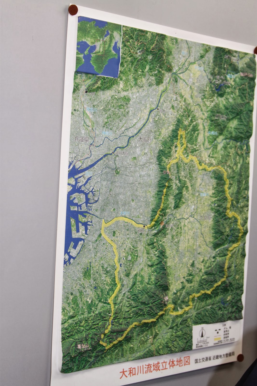
Our final stop was East of Osaka, at the Kamenose landslide area. Since the 1950s, pillars worth 40 million euro each have been put into the mountain. The top sand layer of the mountain has been removed, and an intricate network of tunnels and filters has been installed, all in order to prevent landslides. The Yamato river, whose basin originates in the Nara area, has only one way to flow to the ocean. This is at the Kamenose landslide area, where two mountain ranges are briefly intersected by this river. Should a landslide occur, then the single most transportation route for humans and the river would be cut off as a natural dam would be created, and the Nara area would become a lake. Aside from the information hall, we also got to walk inside one of the tunnels themselves. Strangely enough, after these tunnels are constructed, there is no further removal of soil. Supposedly the inflow is stopped by filters. Afterwards we traveled back by shinkansen once more.