Wednesday, May 23, 2012

Field Trip to Tone weir and ADCP

Despite the cloudy weather, we had a very educational day outside at a Tone river weir and doing some Acoustic Doppler Current Profile experiments.

This weir in the Tone river is near Gyoda city, in Saitama prefecture. It divides part of the water from the Tone river in 3 new river sections, flowing to different areas for drinking water and irrigation. This water is brought to the majority of Tokyo city! The weir also features the most nature friendly fish ladder I have seen so far. What's more, it shows actual proof of success: you can go downstairs next to the fish ladder and look at the jumping fish through a series of windows. They jump so fast, it wasn't possible to catch one on photo, but we saw small fish like sardines and a white fish of about 30 cm long. The MLIT office itself was retrofitted but still showed cracks from an earthquake (or more).


In the afternoon we met an ICHARM researcher at the Taisho Bridge on the Tone river and learned about the ADCP technique. This floating measurement device costs more than a Ferrari, we were told. During an actual flood it must be far more difficult to perform these measurements. The best part of the rainy day was that the bus driver provided us all with umbrellas.


Tuesday, May 22, 2012

Field Trip to dams

Today we visited two dams in the Tochigi prefecture: Ikari and Kawaji dam. In the afternoon we visited Sabo works in Ashio.

What makes the Ikari and Kawaji dam so special is their interconnecting tunnel that runs through the mountain between them. Through this tunnel, 20 cubic meter per second of water can flow from the Ikari to the Kawaji dam during the rainy season, and 1 cubic meter per second of water can flow in the opposite direction during the dry season. We even got to go inside the tunnel and see the three pumps in action. I asked how the pipes were checked for faults and they are in fact so big they get a yearly visual (humanoid!) inspection on the inside. The smaller pipes are checked only on the outside. A small building adjacent to the Kawaji dam hosted a restaurant and two floors of educational models, videos and pictures of the dam site. These dams are quite close to mount Nantai, near Nikko.


Our second visit took us near an abandoned copper mine. Burning the rocks from the mine had created poisonous gasses that killed many trees on the mountainsides nearby, enabling landslides. It also polluted the river area downstream and greatly affected the rice agriculture. After the mine was closed, many things were improved: sabo works to prevent landslides, replanting the hillsides with trees together with schoolchildren, and a dam to slow water flow. Species that had left the area, such as deer, have returned in recent years.


Sunday, May 20, 2012

Field Trip to Tone river drills

20,000 participants gathered today for the Tone river drills. Although the majority consisted of suibo (flood fighting), firefighting and military personnel, this drill is also open to the public. From arrival to departure, everything was catered to.

After arriving on site, guided by about 20 traffic aides, a new bus transported us from the parking lot to the actual drill site. Many vans and stands offered demonstrations, such as knot tying, first aid, typhoon or earthquake simulations, oil absorbing products and inflatable dams. Awareness was also created by one stand where you could put on special glasses that make you experience what a color blind person would see when watching the average map of dangerous sites in green, yellow and red. We walked around between strategically based toilets and five mascots to get to our spot.
The main event was to sit in tents and watch the actual drills unfold (on the screen) in front of us. First of all we enjoyed an opening ceremony with taiko drums, and several speeches in Japanese. The different divisions responsible for flood fighting then reported for duty one by one. Next different drills were enacted, such as over topping and water seepage through the subsoil of the levee. A big difference with the Netherlands, aside from the military precision everyone executes, is the amount of bamboo used in emergency measures. Just as we were set to leave, the military rescue of people on rafts in the river started.


Saturday, May 19, 2012

Field Trip to JMA

Today we visited the Tokyo main office of the Japanese Meteorological Agency, and afterwards join a delegation from Pakistan around the Tone river area.

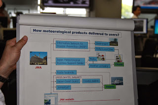
Just like at JAXA, the public can get tours at the JMA to see the actual people at work with only a window between you and the employees. The lecture mainly involved the travel of information between satellites, JMA and the government/public.


In the afternoon we revisited many local MLIT branch offices, and even the Watarase river basin.


Tuesday, May 8, 2012

Hojo Town Tornado Aftermath

Colleagues have taken pictures of the aftermath of the tornado in Hojo Town, at the North of Tsukuba municipality. The destruction is enormous. Below are images showing where Hojo town is in Japan, and a view of the tornado path. It still is hard to believe this is the same place we visited just three weeks back. Many former possessions are already stacked away as trash, and people are fixing their roofs. The Self Defense Force was also assessing damage. Even stone statues of the temples are broken and concrete power lines pushed into the ground.


Tsukuba City Homepage now also had information available in English:


There was a Tornado in Tsukuba City on May 6th (12:45pm)(Updated May 7,2012)
  • Evacuation Places
    1) Oda elementary school
    2) Tai elementary school
  • Where to dispose waste,rubbles, garbage, etc.
    1) Tsukuba community center (South parking area)
    ■8:30am - 17:15pm (every day for the time being)
    • wood/timber, heat insulating material, concrete walls, roof tiles are acceptable.
    2) Clean center
    ■weekdays 8:30am - 16:30pm, Sat 8:30am - 11:30am
    • burnable garbage, non-burnable garbage, home electric appliances are acceptable.
※Please bring the garbage directly to the Clean Center (Tsukuba Mimori 2339, Tel:029-867-1379)
  • Traffic Information
    Bus stops have changed around the Hojo area and around the Tsukuba community center.

The Japanese version of the website shows much more detailed information, including the following table (translated by Google Translate):

Human suffering (human)   Dwelling damage (buildings)
Dead
Missing person
Injured
Hojo district
Daisuna district Nishigoya district 
Yoshinuma district
Serious injuryMinor injury
 One
Zero Zero 37
170 destroyed, 207 partially destroyed, 450 damaged part, a total of 827
(Some of them are also included non-residential buildings such as warehouses, barns)

Almost immediately after the event the emergency volunteer website started to organize volunteer activities (translated by Google Translate):
We will begin registering volunteers to affected areas at this time a tornado occurred in Tsukuba City on May 6. Future, you will be asked to go to activity according to the needs of subscribers from the victims. Asked to perform activities according to your needs, so you may not be able to ask their activities are registered, please understand. Contact Volunteer Center disaster ◆ Tsukuba   Address: (place of study painting two school district town D32) 2530-2 Karima Tsukuba       , Tsukuba City Hall second floor   Phone :029 -883 -1370 ※ Registration time volunteers, 9:00 to 17:00 will be.  Addition, if you know of anyone who made ​​the request of the volunteer activities in Shakyo, we will join the (plan A natural disaster) insurance Shakyo volunteer activities at their own expense.  In addition, households are limited to local areas and, unlike when the earthquake affected areas, many are not coming up still needs volunteers. In addition, the site is located at inconvenient traffic, crowded with a vehicle such as debris removal and restoration work, and had been suffering from traffic congestion. Volunteer coordination, so you will be a request from more activity in accordance with the circumstances and needs of victims of the disaster area, familiar with regional conditions, please register it understands.

The JMA is being cautious and have issued a warning, according to the mainichiThe weather agency cautioned that similar atmospheric conditions that gave rise to the tornados on Sunday could develop over a wide area between Thursday through Friday. 
Let's take care riding our bicycles to work.

More scientific information can be found here.

Sunday, May 6, 2012

Trip to Kokai and Kinu river

We are safe!

Today we returned from a trip to the Kokai and Kinu river. The news when we returned was that Tsukuba had been struck by a tornado. It actually struck the Hojo area North of Tsukuba, where we visited with professor Takeuchi earlier last month. It also caused a power outage, but we have full power here, so it's almost as if nothing happened. The Tsukuba city website is displaying which bus to take to evacuation centers in case you were living in the Hojo area. Over 400 houses are destroyed and 30 people are injured, some severely, and one boy has died. Tornadoes are rare, it is said.

The pictures we took today show stormy skies. Having a holiday, many people were out on the river with jet skis or fishing equipment. At the Fukuoka weir, we nearly were blown off the weir into the water. This was about the time the tornado struck. We stopped at several water in- and outlets going North along the Kokai river. We ended up at the butterfly shaped insect museum, which also features fish and a gallery with pictures and images made from flower petals. At the Aeon shopping mall we saw an agricultural rice planting machine. The next day I heard there was a tornado in Tsuchiura last year, just 10 km South of Tsukuba. It doesn't sound quite so rare.