Sunday, October 30, 2011

Bus Tour to Disaster Prevention Facilities

The final answer to the ultimate question: what is located beneath the houses at Tokyo Decks? Adult diapers! And much, much more.

After departing from the Minato Ward City Hall our group of about 15 people departed for Odaiba, driving across the Rainbow Bridge. We arrived at the Tokyo Rinkai Disaster Prevention Park, where we got a full tour of the facilities and experienced an extremely frightening disaster simulation!


The disaster complex operates as an emergency backup facility in case the regular disaster management centers (such as the one in Saitama visited in the previous trip) have themselves become nonoperational due to a disaster. It can facilitate 246 people in the main communication room (there are two additional rooms), has a diesel operated generator for power supply, has space for 7 helicopters of any size, and lends out sports materials to families for playing on the grounds when there are no drills scheduled. I was very happy to meet another GRIPS student who lives in the Odaiba facilities.


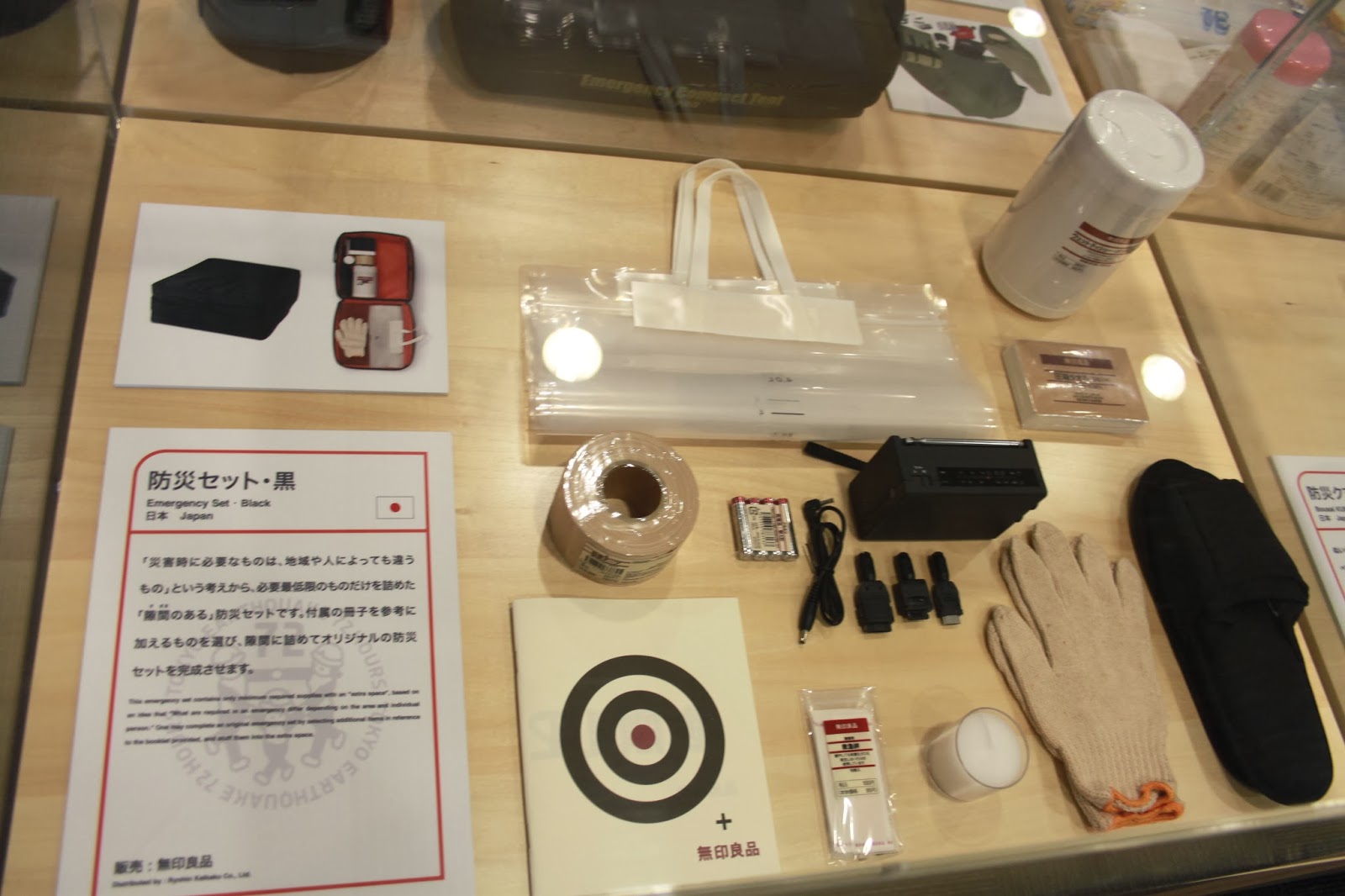
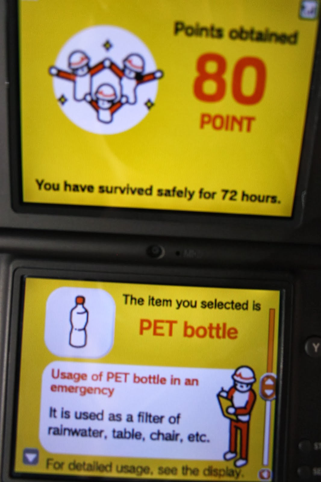
In the exhibition section the emergency survival packages of several different countries are displayed, as well as games from different countries that teach children how to deal with disasters. During our tour our guide Mori-san showed us a new prototype temporary house, explained why this building was extremely safe (there are also anti-liquefaction measures in place), and then we started our Nintendo DS supported earthquake simulation experience.


Basically after a major disaster the governmental support is expected to not be able to reach the affected area for 72 hours. If you are injured or your house is destroyed, you can come to an emergency center for support. If not, you are expected to survive 72 hours in your house or office, by yourself. This tour makes you experience a major earthquake in a warehouse elevator, after which you walk outside in disaster struck streets. All the while you answer questions for the DS quiz, rating your survival. After this, there is a short movie about the roughly 6.5 million people who would have to travel home from their job in case the earthquake strikes Tokyo in daytime. Finally there is a highly educational section with tips on how to survive, using bottles as furniture and folding flyers into cups and plates. Having survived, we got a solar powered key chain light as reward. Outside our attention was drawn toward the panels between the Disaster Prevention building and the surrounding park. These will break and fall down during a major earthquake, due to the special shock absorbers in the building itself.


The second part of the trip led us close to Odaiba's artificial beach and right next to Tokyo Decks. This is one of Minato Ward's Civic Centers. They have public functions like a library, acting stage and rent-able conference rooms, and also have stockpiles for disasters (there are 107 stockpiles in total in this ward). In the Minato Ward there are about 200,000 Japanese inhabitants and 20,000 foreigners. However in day time there are about 900,000 people commuting and working. Currently the facilities are prepared to cater to 40,000 people who are injured or whose house is destroyed in case of a disaster. For this reason Minato Ward has asked the major companies in the district to arrange a stockpile for their own employees.

The director of the Civic Center showed us boxes with carpets, rive, water, gasoline, portable toilets, rescue equipment, first aid kits (medication stored in the refrigerator), radios... a disaster almost seems manageable with this amount of preparation. Of course it only works if people know these places exist. We returned to the Minato Ward City Hall to see the Tokyo Tower lit up beautifully. Today really showed once again how important it is to have an emergency stockpile at home, at the office, and to inform your family beforehand what your plan is when a disaster occurs.


Field Trip to Chuo university, Saitama government office and the Metropolitan Area Outer Underground Discharge Channel

Another field trip today, this time to Chuo university, the Flood Forecasting Center at the Kanto Regional Development Bureau and once again the Metropolitan Area Outer Underground Discharge Channel (首都圏外郭放水路 shutoken gaikaku hōsuiro). I have added some pictures from other students as well.

The trip to Chuo university took us right past the Tokyo Dome and L'Aqua entertainment section, which shouldn't have surprised me. Our lecture was by the number 1 Giants fan, who even says you have to become a paid member of their fan club if you wish to be his PhD student!


At the Flood Forecasting Center we had some time to explore the building, merging modern with nature wherever it can. After lunch we practiced performing serious discussions, and somewhat less serious poses while waiting on the elevators. The Flood Forecasting Center basically does what it sounds like, though it was difficult to get an unambiguous answer as to how inter-regional communications are arranged. As there are several rivers crossing the region's boundaries, this is an intriguing matter.

Third and final came another visit to the Metropolitan Area Outer Underground Discharge Channel (MAOUDC? We need an abbreviation more clear than G-Cans I think...). The tour was shorter than my previous Japanese tour, most importantly due to all students asking questions as ever. Still, I was able to learn something. The amount of dirt you see in the pictures is about the most it could be, as the entire tunnel system is cleaned once a year, at November 1st. It took 13 years to complete building, our guide told us.


Field Trip to Ara river

Today was our first field trip. We went to the Ara river, Super Levee Shinden, the Arakawa Museum Of Aqua, and the Disaster Prevention Station in the Ukima area. Oversea conference visitors might recognize the Ara river Lock Gate as most field trips go to this river. Without a doubt, this is a highly informative location to see river management put into practice.

The Ara river is a man made channel. After a major flood in 1910 the original course of the Ara river was renamed to Sumida river. The new course of flow was mainly constructed by manual and horse labor, and in the last 100 years many people have moved to the new floodplains. At the time, these were safe lands that could not flood, as the river was created to be lower than the surrounding land. However, due to the high population increase, large amounts of groundwater have been pumped up, causing land subsidence. Today, the floodplains house over 10,000 inhabitants per square kilometer and the ground has subsided considerably, making many people vulnerable to floods. Hence the need for super levees.


 Visiting the Super Levee Shinden was amazing, as I had gotten the Japanese information about these areas some years ago and I was eager to finally see it. The new government has authorized only a minor part of the initial plan of > 400 km of super levees to be constructed. As a consequence there are now parts of the river with super levees and parts without super levees. The whole idea is that the super levee has a less chance of breaking during floods, so I wondered how the interaction of these different areas was imagined. What if a normal levee breaches and the water pours in at the backside of the super levee? Our guide reassured us that this could not happen, as the non-super levee parts were reinforced against water seepage underneath. However, he added, if the water came to high, there was no additional protection against over-topping at the moment.


In the Arakawa Museum Of Aqua (AMOA) you can see the history of the Ara river yourself, along with an impressive movie about the triple disaster of March 11, mainly focusing on the tsunami. The Disaster Prevention Station has storage material in case of floods, mainly for river engineering itself. There is rubble and foot protection blocks in case of an imminent river breach. Luckily the material at the station has not had to be used as of yet. Today was very informative, and it was nice to see the various activities that could be performed in the floodplains next to the river on this sunny day.