Tuesday, July 30, 2013

News in Japan - July

GEJET
Floating Wind Turbine Arrives in Fukushima
Japanese 'miracle' pine returns to tsunami-hit town
Japan's tsunami debris litters Canadian shore
Regulators suspect toxic water at Fukushima plant contaminating sea
Steam seen coming out of Fukushima Daiichi No. 3 reactor building
Operator of crippled Japan nuke plant says likely that radioactive water leaking into sea
Fukushima reactor site engulfed by steam

Floods in Europe
Placing Flood Mitigation On Four Pillars: Conclusions from 2013 Central European Floods

Japan

Netherlands

Social

Other

Tuesday, July 23, 2013

Field trip to Niigata - day 3

On the final day of the Niigata field trip we attended lectures at Sanjo city by the municipality and the flood-fighting corps. In the afternoon we visited three more local sites.

At Sanjo city hall, we received much information on local disaster management. For instance, the town has prepared several different disaster manuals for different groups of people, among which one in English and one in Chinese for foreign residents. During the 2004 flood, 7 out of the 9 deaths were elderly. The city is currently constructing a list of information of non self-reliant people, although this process is still delicate as many people feel it disturbs their privacy. The city now automatically puts certain people receiving certain healthcare measures on the list of special evacuation care, unless they object to it. In this case, they will receive no special help during evacuations and must make their own preparations.


After the lectures we went to the Kariyata disaster prevention park, a paddy field, and a retarding basin.
At several sites in the town we saw flood prevention measures, including signs indicating previous flood heights. Twice a year the soil quality of the river is tested, and if approved it is dredged and used to heighten the embankments.


In the paddy field we were introduced to the tanbo dam concept that has helped reduce the flood peak of rivers by an altered shape of paddy field drainage. This way the water is retained for a longer period by the paddies and the flood peak is lowered.


Finally it was time to return home by shinkansen, through the paddy fields.


Field trip to Niigata - day 2

On the morning of the second day of the field trip to Niigata, the local MLIT officers explained about the flood countermeasures in the prefecture, while in the afternoon a prefectural officer guided us along the river to visit the locations and see the implementations.

Niigata prefecture has had many flood disasters in the past decade. Notable floods occured in July of 2004 and 2011. Both times, the affected areas received countermeasures, and since the GEJET even more measures are taken, even specifically for vulnerable people. While the shelters aren't currently prepared for people with medical complications, it is being discussed how to prepare them. Neighborhood associations help people perform drills and transport those who need help to the evacuation shelter. 


Issues for which there are no solutions yet are the lack of a unified coloring system to indicate the different levels of 'flood danger level' and 'evacuation decision level'. The flood hazard maps are also not checked for legibility by color blind people. 

In the afternoon, the locations we visited included the Sekiya diversion channel, the shinano river water gate (see below), the toyano pumping station (see below), Kosudo bridge and levee, the water level observatory, Idoba levee (see picture), Ikarashi river, and a breach point of the 2004 flood. 


Interestingly, while floods due to heavy rainfall in Niigata prefecture usually affect a major part of the basin, Sabo island just off the coast does not suffer similar amounts of rainfall and flooding at the same time. This is due to the difference in height of the mountains and prevailing winds.


Sunday, July 21, 2013

Field trip to Niigata - day 1

As part of the IFAS training at ICHARM, we participated in a field trip to Shinano river. Shinano river, on the North West coast of Japan, is the longest of Japan with 367 km. It also has the third largest catchment area with 11,99 km2, following Tone and Ishikari river. In sharp contrast with Tone river in the Kanto area, the population in the river basin is 2.9 million, about half of which live in Nagano prefecture and half in Niigata prefecture. Niigata prefecture is famous for rice and the main rice producing area of Japan.


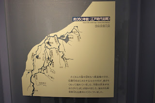
The first place we visited in Niigata was the Shinano River Oukouzu museum, which explains about the Oukouzu diversion channel. This channel was built in response to the heavy floods and lies roughly in between the cities Nagaoka and Sanjo. There were plans to create a channel since the early 1700s, but it took several more floods for the plans to be accepted. In 1869 construction started and in 1931 the channel was completed. Below you can see the historical coastline of Niigata prefecture, a model of the dam situation and the actual dam with a fish ladder. 


Secondly we visited Niigata city, on the coast of Niigata prefecture where Shinano river meets the ocean. At the top of the Toki Messe building we had a good view of the river and the city, and even Sado island just off the coast.