Saturday, December 31, 2011

Earthquakes Japan 2011

This is an overview of all the earthquakes in Japan in 2011, sorted per magnitude and shindo (震度, shaking intensity). This data was generated by using the Japan Meteorological Agency database.


The most earthquakes in a single category were shindo 1 and magnitude 3-3.9, nearly ten times more than last year.
Shindo 1 earthquakes ranged from magnitude 0 to 6.9.
Shindo 2 earthquakes ranged from magnitude 1 to 6.9.
Shindo 3 earthquakes ranged from magnitude 2 to 6.9.
Shindo 4 earthquakes ranged from magnitude 2 to 7.9.
Shindo 5- earthquakes ranged from magnitude 3 to 7.9.
Shindo 5+ earthquakes ranged from magnitude 4 to 6.9.
Shindo 6- earthquakes ranged from magnitude 5 to 7.9.
Shindo 6+ earthquakes ranged from magnitude 6 to 7.9.
The Shindo 7 earthquake was magnitude 9.0.

Below the frequency distribution of earthquakes during the year is shown:


Comparing the JMA statistics with the data from their database, 73 earthquakes were missing from the data in the database (44 of shindo 1, six of shindo 2, and one of shindo 3).

JMA:
Intensity 震度7 震度6強 震度6弱 震度5強 震度5弱 震度4 震度3 震度2 震度1 Total
2011 1 4 4 17 45 253 976 2863 6518 10681

Database:
Intensity 震度7 震度6強 震度6弱 震度5強 震度5弱 震度4 震度3 震度2 震度1 Total
2011 1 4 4 17 45 253 975 2857 6452 10608

Monday, December 12, 2011

Field Trip to Tsurumi River in Yokohama

Last Friday we had a four stop field trip all the way down to Yokohama. Our first stop was at the Tsurumi River Basin Information Center. First we had an informative lecture by Masahiro Imbe. His last name is very special, not sounding like the common Japanese names referring to natural surroundings. He told me only a few Japanese families originally had last names. His is a very ancient family line, connected to priests coordinating rites in the temples. He also mentioned that at one point in time he visited the Netherlands and he even met the grandson of the famous Johannes de Rijke.
During the lecture we learned that the current safety levels of the Tsurumi River are being revised by the national government to take the speculated effects of climate change into account. It is one of the 17 rivers that are completely under the governance of the governments MLIT, so there is no prefectural coordination needed (Tsurumi River starts in the Tokyo Metropolitan prefecture before having most of its basin in Kanagawa). There are some control issues. Both the river division and the sewer division are responsible for creating more water storage, but since communication is difficult between these two organizations, it is unknown how much water the measures of the sewer division are storing exactly.
Did you know the Tsurumi River basin is conveniently ‘tapir-shaped’? The tapir is thus the mascot, and gets dressed up for holidays. As usual for river information centers, there were crabs and fish to see and touch, a marble basin where you could drop blue marbles representing water drops (which had some trouble travelling downstream), and a huge floor map where locals can find their house. Araki-san, our faithful translator, helped with all the explanations, such as the story of the tsunami from March 11 going up the river.


The Tsurumi River Basin Information Center is next door to the Nissan soccer stadium where the 2002 world cup was held. On December 18th the finals of the FIFA Club World Cup will be held there, and it's the biggest stadium in Japan. In fact the stadium is inside the basin area, but the water will flow between the pillars it is standing on. The nearby hospital is outside the basin area. In the West (upstream) there is a lowered dyke functioning as an overflow levee. In the East (downstream) there is a drainage gate.


Our second stop was at the Kirigaoka Regulating Pond. Currently in use as tennis court, this reservoir has two inlets and one major outlet with a dam. I noticed I have now been to practically all places that I saw in a presentation three years ago, when Koichi Fujita visited our university in the Netherlands. Maybe the final stop will be at the Yodo river in Osaka?


Next was the Onmawashi Park Underground Tunnel-type Reservoir, an underground tunnel with a dead end. Water enters and exits at the same location, albeit with some height difference. Only the above ground area is accessible, but this has an interesting information building with models and a video. The inlet can be seen as well.


Finally we came to Professor Takahashi’s house where we saw a rainwater storage and infiltration system. Four cubic meters of rainwater can be stored and used to flush the toilet or do laundry. This saves some money on water. It also costs a bit of money to pay for the electricity to use the water pumps, but this amount is smaller, so in the end some money is still saved.


Thursday, November 24, 2011

Field Trip to West Tokyo

On Tuesday we visited river improvement areas near Shirakogawa and Shakujigawa in Western Tokyo.
With the skies being at their utmost clarity, we could see Mount Fuji from the bus (zoom in on the largest cloud shape to see it). It's hard to imagine I was standing on top of it a mere four months ago. Capturing the mountain provided a good morning bus ride activity, after which we arrived at the Tokyo Metropolitan Government Planning Section River Department Construction Bureau. (They do like to use multiple lines on business cards.) Aside from highly informative lectures - did you know Tokyo receives twice the global mean annual rainfall? - we got to see the improvement constructions ourselves. It was something altogether unexpected.


I had no idea another underground basin was in store for us. It appears to be bigger than the last basin at the G-Cans, but it is hard to estimate volume in a three dimensional maze like this. There were some small differences in maintenance compared to the G-Cans as well, aside from the multitude of pillars used here. There are air vents running halfway through the hall, water can flow onto the electrical system of the pumps, there is water running through cracks in the ceiling, and strung around the water entrances are CD's failing to deter pigeons.


After having another look at the downstream flood control reservoir, but now from the outside, we went on to the construction site of the new underground shaft at Shirogawa. A second shaft at Shakujigawa and a connecting tunnel have yet to be finished, but here comes the biggest difference with the G-Cans: due to flooding at both Shirogawa and Shakujigawa sites, it has been decided to finish the design in such a way that the water can enter and exit at both ends! Engineering gemstones, that.


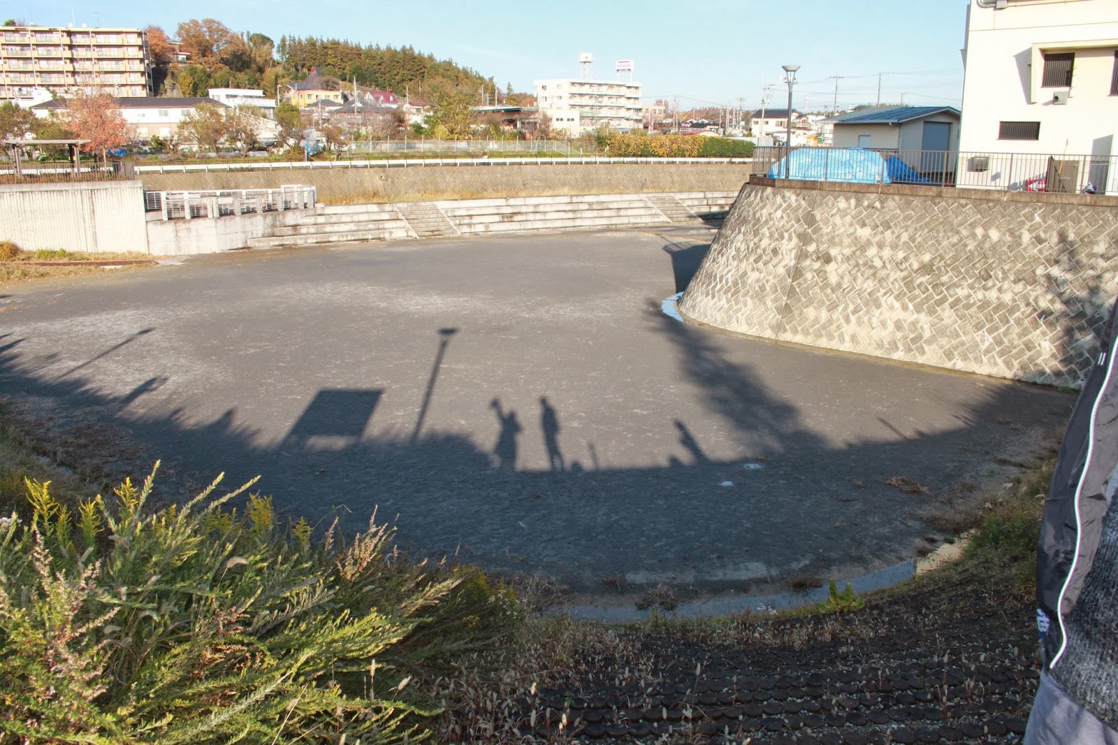
We went on to the upstream reservoir. Slightly less deep to avoid draining water from surrounding hills, it doubles as a tennis court and soccer field. We also witnessed the enlargement of river revets, aka concrete dikes holding the water in place. The unfortunately necessary trimming of sakura trees aligning the river was taken into account in the construction plans, of course. Final point to note is the exceptional handling of the Shirakogawa, as it lies in two prefectures instead of one (most rivers lie in only one prefecture; it saves a lot of hassle). Saitama and the Tokyo Metropolitan Government are performing joint planning and agreed on a design level of 50 mm/hour rainfall for this river. Allegedly there are joint decisions and many communications, though I have only heard this from one party. Theory and practice in governance, and most importantly the definition of responsibilities, can differ a lot here. It was a great opportunity to see joint plans put into action though.


Sunday, October 30, 2011

Bus Tour to Disaster Prevention Facilities

The final answer to the ultimate question: what is located beneath the houses at Tokyo Decks? Adult diapers! And much, much more.

After departing from the Minato Ward City Hall our group of about 15 people departed for Odaiba, driving across the Rainbow Bridge. We arrived at the Tokyo Rinkai Disaster Prevention Park, where we got a full tour of the facilities and experienced an extremely frightening disaster simulation!


The disaster complex operates as an emergency backup facility in case the regular disaster management centers (such as the one in Saitama visited in the previous trip) have themselves become nonoperational due to a disaster. It can facilitate 246 people in the main communication room (there are two additional rooms), has a diesel operated generator for power supply, has space for 7 helicopters of any size, and lends out sports materials to families for playing on the grounds when there are no drills scheduled. I was very happy to meet another GRIPS student who lives in the Odaiba facilities.


In the exhibition section the emergency survival packages of several different countries are displayed, as well as games from different countries that teach children how to deal with disasters. During our tour our guide Mori-san showed us a new prototype temporary house, explained why this building was extremely safe (there are also anti-liquefaction measures in place), and then we started our Nintendo DS supported earthquake simulation experience.


Basically after a major disaster the governmental support is expected to not be able to reach the affected area for 72 hours. If you are injured or your house is destroyed, you can come to an emergency center for support. If not, you are expected to survive 72 hours in your house or office, by yourself. This tour makes you experience a major earthquake in a warehouse elevator, after which you walk outside in disaster struck streets. All the while you answer questions for the DS quiz, rating your survival. After this, there is a short movie about the roughly 6.5 million people who would have to travel home from their job in case the earthquake strikes Tokyo in daytime. Finally there is a highly educational section with tips on how to survive, using bottles as furniture and folding flyers into cups and plates. Having survived, we got a solar powered key chain light as reward. Outside our attention was drawn toward the panels between the Disaster Prevention building and the surrounding park. These will break and fall down during a major earthquake, due to the special shock absorbers in the building itself.


The second part of the trip led us close to Odaiba's artificial beach and right next to Tokyo Decks. This is one of Minato Ward's Civic Centers. They have public functions like a library, acting stage and rent-able conference rooms, and also have stockpiles for disasters (there are 107 stockpiles in total in this ward). In the Minato Ward there are about 200,000 Japanese inhabitants and 20,000 foreigners. However in day time there are about 900,000 people commuting and working. Currently the facilities are prepared to cater to 40,000 people who are injured or whose house is destroyed in case of a disaster. For this reason Minato Ward has asked the major companies in the district to arrange a stockpile for their own employees.

The director of the Civic Center showed us boxes with carpets, rive, water, gasoline, portable toilets, rescue equipment, first aid kits (medication stored in the refrigerator), radios... a disaster almost seems manageable with this amount of preparation. Of course it only works if people know these places exist. We returned to the Minato Ward City Hall to see the Tokyo Tower lit up beautifully. Today really showed once again how important it is to have an emergency stockpile at home, at the office, and to inform your family beforehand what your plan is when a disaster occurs.