Wednesday, December 30, 2015

Earthquakes Japan 2015

This is an overview of all the earthquakes in Japan in 2014, sorted per magnitude and shindo (震度, shaking intensity). This data was generated by using the Japan Meteorological Agency database.


The most earthquakes in a single category were shindo 1 and magnitude 3-3.9.
Shindo 1 earthquakes ranged from magnitude 0 to 6.9.
Shindo 2 earthquakes ranged from magnitude 1 to 6.9.
Shindo 3 earthquakes ranged from magnitude 1 to 6.9.
Shindo 4 earthquakes ranged from magnitude 3 to 7.9.
Shindo 5- earthquakes ranged from magnitude 5 to 5.9.
The Shindo 5+ earthquake fell into magnitude 5 to 8.9.

Below the frequency distribution of earthquakes during the year is shown (click to enlarge):

Friday, December 25, 2015

News in Japan - December

Japan:
556 bridges found to have bad supports:The devices are supposed to keep the bridges from collapsing during major earthquakes.

USA:
Key elements of digital disaster communications demystified: Messages describing hazard impacts and emphasizing cohesion among users generated the most "retweets". Other elements encouraging retransmission include the number of users in an agency's network and the inclusion of an agreed-upon hashtag. "Shorter messages are not necessarily simpler to write," said lead author Jeannette Sutton, director of the University of Kentucky's Risk & Disaster Communication Center. "We have decades of research on longer warning messages and practically none on short messages. 
Texas tornadoes: Eleven killed in Dallas area: Eleven people have been killed in tornadoes in Texas, police say, with heavy rain and snow causing deaths and disruption in a number of other states. Further north, six people died in two incidents when cars drove into flooded roads in Missouri. Another driver was found dead in his car in a creek. Three adults and two children also drowned in southern Illinois when their vehicle was swept away.

Other:
Heavy floods in parts of South America (Dutch):Nearly 150,000 people in Paraguay, Argentina and Uruguay were forced to leave their houses due to floods. Most heavily affected was Paraguay (130,000 people), where a state of emergency has been declared and the president has already dedicated over 3 million euro as response funds. Over 125,000 people have lost power to their homes. Five people have died (4 from falling trees and one from electrocution).

According to the methods used in my latest published paper, these victims would not technically be counted as flood victims, as in that study, we excluded cases where victims died of causes unrelated to floods [such as being crushed by trees, falling from roofs, being blown off the road, or receiving electric shocks, and we found that 38% (122 victims) of the data relating to the 325 victims consisted of causes of death such as drowning (hypothermia or asphyxiation), heart attacks, or physical trauma during evacuation].
Vegetarian and 'healthy' diets are more harmful to the environment: "Eating lettuce is over three times worse in greenhouse gas emissions than eating bacon," said Paul Fischbeck, professor of social and decisions sciences and engineering and public policy. "Lots of common vegetables require more resources per calorie than you would think. Eggplant, celery and cucumbers look particularly bad when compared to pork or chicken." eating the recommended "healthier" foods -- a mix of fruits, vegetables, dairy and seafood -- increased the environmental impact in all three categories: Energy use went up by 38 percent, water use by 10 percent and GHG emissions by 6 percent.

Vulnerable People:
Child poverty could cost Japan $33 billion: The group predicted how their job prospects and lifetime earnings could change in 2 scenarios. One is that the government offers them assistance to go to high schools or colleges. The other is that the government doesn't take any action. The organization says the government's inaction would reduce the number of regular employees by 9,000 and leave 4,000 unemployed. It notes that this could result in a loss of about 24 billion dollars in their income, compared with when the government took action.


Monday, December 21, 2015

Published Paper

The journal Water Policy has published an article by Sangeun Lee and myself titled "Assessing the vulnerability of different age groups regarding flood fatalities: case study in the Philippines". It is now available online in final form (a previous version was available in May). Although this publication is not open access, full PDF copies are available upon request.

Abstract (adapted to adjust html codes to proper screen coding)
This study aimed to identify age groups vulnerable to flood fatalities and quantify their vulnerability by means of statistical methods. First, the study obtained data of 122 victims directly resulting from five flood disasters in the Philippines over the period 2010–2013 which was used to compare the number of flood fatalities in each age group with the population numbers. The chi-square goodness-of-fit test shows that only one age group, people aged less than and up to 70, was vulnerable to flood fatalities. Vulnerabilities of people aged less than and up to 70 and over 70, respectively, were quantified in terms of mortality, i.e., the ratio of flood fatalities and affected people. This study obtained two lognormal distribution curves moderately describing histograms built with samples on the mortality of the two age groups. Based on probabilistic parameters of the selected lognormal distribution curves, the study concludes that people aged less than and up to 70 have more than three times the vulnerability to the risk of flood fatality than people aged over 70. It is also suggested that the age dependency ratio, which is widely used to consider demographic vulnerability in flood vulnerability studies, should not be applied to the Philippines.


Journal ref: Water Policy, December 2015, 17 (6) 1045-1061
Received: 12 May 2014
Accepted in revised form: 19 February 2015
Published online (uncorrected proof): 13 April 2015
Available online: 17 December 2015
DOI:10.2166/wp.2015.089
Impact Factor 2014: 0.833

Thursday, December 17, 2015

UNESCO ENHANS project meeting

ENHANCING NATURAL HAZARDS RESILIENCE IN SOUTH AMERICA

At this meeting Masahiko Murase from ICHARM explained the research and education activities at ICHARM, and Karina Vink showed three models used for different project: BTOP, IFAS and RRI. 

A program specialist of UNESCO requested more technical requirements of an IFAS training for the four target countries of the ENHANS project. The ENHANS project currently has as target countries: Ecuador, Chili, Peru, Uruguay. The first target for IFAS training would be Chili/Peru, possibly simultaneously as the target areas in these countries border each other (North Chili, South Peru). As training period May was suggested. 

The ENHANS meeting in Montevideo was successful as multiple parties expressed an interest in IFAS training and ICHARM models. As a next step a governmental request for IFAS training would aid in arranging the necessary required administrative steps and financing surrounding the organization of IFAS trainings abroad. ICHARM will continue to support and prepare for IFAS training in the ENHANS target countries if so requested.

Friday, November 27, 2015

News in Japan - November

Japan:
Study says Tokyo, Osaka, other mega-cities will be swamped by surging sea levels, even at 2 degrees Celsius rise A spike in Earth’s temperature of 2 degrees Celsius (3.6 degrees Fahrenheit) would submerge land currently occupied by 280 million people, while an increase of 4 degrees Celsius - humanity’s current trajectory - would cover areas populated by more than 600 million people, the study said.
In the capital, 7.5 million people - 30 percent of Tokyo’s population - would be affected by the sea level rise under the 4 C scenario. A rise by 2 C would leave 4.2 million people’s homes underwater.
In Osaka, 6.2 million people - a staggering 38 percent of its population - would be affected under the 4 C rise. Under the 2 C scenario, the city would still see 4.2 million affected.
Sea level rises corresponding to these 2 C or 4 C scenarios could unfold in two hundred years, but would more likely happen over many centuries, perhaps as long as 2,000 years, according to the research, published by Climate Central.

USA:
Study ranks six American cities on preparation for climate change
Houston-Galveston region could be better protected from impact of hurricanes and severe storms

Netherlands:
Room for the river programme completes its largest depolderingproject Noordwaard, the Netherlands
Current technologies for levee monitoring in the Netherlands

Other:
Images Show Impact of Sea Level Rise on Global Icons
Paying it forward in a digital age: A global community committed to a mapped world
Salmon crossing the road during flood

Published paper

Environmental Hazards has published the article 'Factors affecting the evacuation decisions of coastal households during Cyclone Aila in Bangladesh', of which I am proud to be co-author.

You can use this link to receive a free full copy, or find it here if you have access to the journal.

Abstract
Despite sincere efforts by concerned agencies and recent improvements in hazard warnings, thousands of at-risk people did not evacuate during Aila, a category-I tropical cyclone that struck southwestern coastal Bangladesh in 2009. This study investigated the responses of the people affected by Aila to cyclone warnings and associated evacuation orders, and unveiled behavioural aspects that explain why they did or did not comply with the evacuation orders. Utilising the primary data collected from 420 households living in the severely affected coastal sub-district Koyra, located in Khulna District, this study found that although more than 97% of the households had received cyclone warnings and evacuation orders before Aila's landfall, only around 26% had evacuated. We also examined this study's empirical findings for factors that had dissuaded people from complying with the evacuation orders. Relevant test statistics along with results from principal component analysis suggested that the significant and systematic absenteeism of households from disaster preparedness training appears to be one of the key determinants that affected their evacuation decisions, along with factors related to warning messages, the attributes of cyclone shelters, risk perception, and socioeconomic aspects. A number of recommendations are also presented in this study for people at risk to improve their evacuation rates in future emergencies, not only to save their own lives but also to save their livestock.


Journal ref: Environmental Hazards
Authors: Md. Nasif Ahsan, Kuniyoshi Takeuchi, Karina Vink & Jeroen Warner
Volume 15, Issue 1, 2016, pages 16-42
Received: 7 January 2015
Accepted: 28 October 2015
Published online: 26 November 2015
http://dx.doi.org/10.1080/17477891.2015.1114912
2014 Impact Factor: 0.868

Friday, November 20, 2015

Joso flood damage overview


The total damage costs are still being calculated as the Japanese fiscal year runs until April, but below a translated overview of the gathered damages so far can be found (click to enlarge).

Friday, October 30, 2015

News in Japan - October

GEJET:
TEPCO rejected requests for anti-tsunami steps before nuclear crisis
First cancer case confirmed from Fukushima cleanup

Japan:
Behind the Scenes / Concern for privacy of Joso missing excessive
Volunteers mucking in to help Japan clean-up

USA:
Hurricane Patricia Recap: Strongest Landfalling Pacific Hurricane on Record
Flood risk on rise for New York City, New Jersey coast, study finds
One-two punch of rising seas, bigger storms may greatly magnify US East coast floods

Netherlands:
Pop-up Exhibition in Dordrecht on potential flood disasters

Other:
In dryland African regions, limiting wildlife water access can reduce water quality
NASA studying 2015 El Nino event as never before
Want To Know How Sea Level Rise Will Impact Your Hometown? There’s A Map For That
Surging seas mapping progress
Researchers work on model to help restoration managers with decision-making (USA, Germany)
Why some scientists are worried about a surprisingly cold ‘blob’ in the North Atlantic Ocean
Work starts on Sendai indicators

Vulnerable People:
Japan’s child poverty above OECD average
Shibuya Ward to begin accepting applications for 'same-sex partnership certificates'

Japanese flood and landslides:
Here are the latest statistics from the Japanese government's Fire and Disaster Management Agency and other national and local governments as of Friday, Sept. 18:
•        The death toll is eight: three in Tochigi Prefecture, three in Ibaraki Prefecture, and two in Miyagi Prefecture.
•        There are 46 confirmed injuries, with Ibaraki Prefecture accounting for 24 of them.
•        A total of 18,882 dwellings have been confirmed flooded. Ibaraki leads this list as well, with 12,088 flooded homes.
•        In addition to the flooded homes, 16 dwellings have been destroyed and another 102 have structural damage.
•        Damage also occurred to 61 non-residential structures.
•        Damage to the agricultural, forestry and fishing industries has reached 11.7 billion yen (about 98 million U.S. dollars).
•        At least 455 landslides were reported – 358 of them in Tochigi Prefecture alone, and 312 of those in the city of Nikkō, according to the prefectural government.
•        Up to 26 inches of rain fell in eastern Japan Sunday through Friday due to Tropical Storm Etau and its remnant low.
•        Local officials in Ibaraki Prefecture said 1,344 people had been rescued via helicopter by the country's Self-Defence Force and rescuers from 10 of the country's 47 prefectures.
Key developments in the storm:
•        On Wednesday, Sept. 16, officials confimed the death of a 40-year-old man who had been out on his bicycle when the floods hit Ibaraki Prefecture on Sept. 10.
•        A 60-year-old man was found dead Saturday after the vehicle he was in was swept into a flooded river Friday morning in the city of Kurihara, Miyagi Prefecture. A 48-year-old woman also died in that incident.
•        Japanese media said a pair of eight-year-old boys were among those found alive and removed from the list of missing Saturday.
•        Two men, ages 71 and 51, were found dead in rice fields flooded by the levee breach in Joso, according to public broadcaster NHK. The men were not previously among the list of missing.
•        The Japanese government's Fire and Disaster Management Agency confirmed that a man found dead in a flooded vehicle in Tochigi Prefecture Sunday morning died of storm-related causes.
•        A 63-year-old woman was confirmed dead after a landslide struck Kanuma city, Tochigi Prefecture, early Thursday. The woman was missing for hours before being found dead Thursday evening.
•        A man in his 20s was confirmed dead Friday after falling into a flooded drainage pipe Thursday in Nikkō city, Tochigi Prefecture.
•        Rare emergency weather warnings were issued for Tochigi, Ibaraki and Miyagi prefectures on Thursday and Friday, but have all since been lowered.
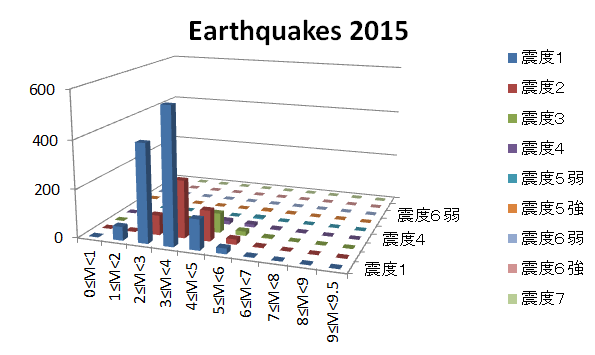
•        A magnitude-5.2 earthquake struck Tokyo Bay at 5:49 a.m. local time Saturday, rattling the entire Tokyo region and prompting fears of quake-triggered landslides in rain-soaked hilly terrain.
•        The earthquake injured seven people in Tokyo and its suburbs, according to the FDMA.
•        Another earthquake, rated magnitude 4.6 and centered off the east coast of Ibaraki Prefecture, rattled the Joso flood zone nearly six hours later but with weaker ground shaking.
•        The Shibui River broke through a levee in Ōsaki city, Miyagi Prefecture, on Friday morning. At least 1,000 people were stranded in floodwaters, according to the newspaper Asahi Shimbun.
•        The Japan Meteorological Agency issued the maximum "Level 5" flood warning Friday for the Yoshida River in Miyagi Prefecture and for the Mogamiogumi River in Yamagata Prefecture.
•        More than 800 people in the mountainous town of Minamiaizu, Fukushima Prefecture, were cut off from the outside world due to flooding and landslides on the lone highway through town Friday.
The Japan Meteorological Agency issued a rare emergency heavy rainfall warning for Miyagi Prefecture and its 2.3 million residents early Friday as torrential rains continued to drench the prefecture, which includes the city of Sendai, raising concerns of landslides and river flooding. The JMA observation site near Sendai's central business district reported 269 millimeters (10.59 inches) of rain in the 24-hour period between 7:40 a.m. Thursday and 7:40 a.m. Friday local time. (Japan is 13 hours ahead of U.S. Eastern Daylight Time.) JMA lowered the warning for Miyagi Friday evening.
"We can say this is an abnormal situation and there is imminent serious danger," said Takuya Deshimaru, chief forecaster at the Japan Meteorological Agency, according to the BBC.
On Thursday, JMA issued similar emergency weather warnings for 5 million people in Tochigi Prefecture and Ibaraki Prefecture, north and northeast of Tokyo, on Thursday morning. The warnings were issued as a band of heavy rainfall associated with the post-tropical remnant of Tropical Storm Etau stalled over eastern Japan, dumping up to 21 inches of rain in 24 hours near the head of the Kunigawa River, which drains south through the northern suburbs of Tokyo.
The emergency warnings in Tochigi and Ibaraki prefectures were lowered Friday morning.

Friday, October 16, 2015

Joso flood videos

Our colleague Dr. Ohara has shared videos made after the Joso city flood disaster.

The first video is taken on September 12th, two days after the flood occurred. This was taken in the North area, at the levee over-topping area, where solar farms were damaged.

Thursday, October 8, 2015

Population preparedness in Europe

September's edition of Crisis Response featured an article on the disaster preparedness of the population in France, Belgium, UK, Portugal, the Netherlands, Greece). It proved what was generally known: people are mostly unprepared and expect the government to come save them.


Read more on how the study recommends to use social media to gather and distribute accurate disaster information at the Crisis Response journal. 

Wednesday, September 30, 2015

Joso flood field survey photos

ICHARM held a field survey in the affected area of Joso city on 17 September 2015. Ibaraki prefecture released an overview of the events and responses on 30 September 2015, including the following information on Joso city:

Number of deaths: 2
Number of injured people: 2 seriously, 11 medium, 17 lightly

Number of people missing: 0
Number of houses flooded above floor level: 4851
Number of houses flooded below floor level: 6600
Evacuees from Joso city: 504 (202 in Joso, 302 in other cities’ shelters) 


Monday, September 21, 2015

Joso city flood GSI information

The Geospatial Institute in Tsukuba has made a huge amount of maps available regarding this flood. I highlighted a few of them in this post. Check their website for more detailed information and presentations (in Japanese). Land use maps are also available.

Most easy to understand are these before/after and during/after maps:
before/after
during/after

They also show the progression of the flood through time on aerial photos (click for larger version):

The affected houses and agricultural areas are well documented, and the elevation map shows the bowl structure the city lies in between the two rivers Kinu (West) and Kokai (East). The north point experienced over-topping, the south point experienced a levee breach.

Friday, August 7, 2015

Visit to the Metropolitan Area Outer Underground Discharge Channel - part 4

Finally some photos from outside, underground in the channel itself, and the pumps in the main building. 


More information from previous visits to the MAOUDC can be found in these posts from August 2011 - August 2011 information - October 2011.

Visit to the Metropolitan Area Outer Underground Discharge Channel - part 3

We enjoyed watching the English video about the MAOUDC with students from the Tokyo University international summer course, who are learning to use the IFAS software at ICHARM this week. 
 
The command center from which the water volumes in separate sections can be managed.


 It was a cool 20 degrees at the bottom of the tunnel.


Visit to the Metropolitan Area Outer Underground Discharge Channel - part 2

Not much has changed since my visits in 2011, but I did get the chance to take more pictures of the information boards in the hallway. 

The first map, with North to the left, shows the projects in the Edo river including super levees.


The next boards elaborate on the concept of super levees. Ideally the whole bank will be completed, but due to financial and political constraints it remains an ongoing process. Another impacting factor is that the prefectural boundary is chosen at the river course, so theTokyo Metropolitan Government is developing super levees on the west side of the river and not the opposite side.


This board shows the river disaster preparedness center.

Finally, something about the MAOUDC itself.

Here the water distribution between Edo, Naka and Ayase river is explained (more pictures of projects of lowland rivers in Tokyo here).

The various areas in Tokyo affected by the Edo river are shown on the right hand side.

This board goes far back into history, showing Tokyo bay 9,000, 5,500 and 4,000 years ago. The landscape and overall shape of the bay have changed dramatically, both enlarging and decreasing in size. As there used to be an inland sea, during the channel construction many sea shells and other remains of marine life were excavated.


The MAOUDC is chosen as one of the locations to see mount Fuji from.

A better picture of the 3D elevation map, showing the bowl structure Tokyo is in and how elevated the river levees are compared to the surrounding landscape. 

Thursday, August 6, 2015

Visit to the Metropolitan Area Outer Underground Discharge Channel - part 1

Members of the ICHARM Risk Team joined with the students from the Tokyo University international summer course, who are learning to use the IFAS software at ICHARM this week, to visit the MAOUDC.

Already at the rest stop there were informative boards from the MLIT on places we visited before, including super levees, the statue in honor of the Dutch engineer Anthonie Rouwenhorst Mulder at the Nagareyama canal that connects the Tone and Edo rivers, and the discharge channel itself.


Here are links with more information from previous visits to the MAOUDC in August 2011 - August 2011 information - October 2011 and comparable underground storage facilities in November 2011.

Friday, July 31, 2015

News in Japan - July

GEJET:
Gov't to lift evacuation order on Fukushima town on Sept 5  Naraha's 7,400 citizens will be the first evacuees to be able to return home permanently among seven municipalities where the entire population was ordered to leave. However, evacuees have mixed feelings about going back to their hometown due to concerns over radiation and lack of medical care, and it was not clear how many of them would return. "There are no shops. There are no doctors. I don't know what to do," a woman told local media on Tuesday. In April, the government started to allow Naraha evacuees to return home for three-month stays to prepare for permanent return.

Japan:
Mount Fuji climbers urged to protect themselves against volcanic eruption The Yamanashi prefectural government placed 1,500 sets of helmets, goggles and dust-proof masks on the fifth station of the Fuji Subaruline toll road. The Fujiyoshida city government also prepared 1,000 of the sets in mountain lodges.

USA:
Major midwest flood risk underestimated by as much as five feet, study finds  As floodwaters surge along major rivers in the midwestern United States, a new study from Washington University in St. Louis suggests federal agencies are underestimating historic 100-year flood levels on these rivers by as much as five feet, a miscalculation that has serious implications for future flood risks, flood insurance and business development in an expanding floodplain.
Researchers find reasons behind increases in urban flooding (USA)
The Really Big One When the next full-margin rupture happens, that region will suffer the worst natural disaster in the history of North America.FEMAprojects that nearly thirteen thousand people will die in the Cascadia earthquake and tsunami. Another twenty-seven thousand will be injured, and the agency expects that it will need to provide shelter for a million displaced people, and food and water for another two and a half million. We now know that the odds of the big Cascadia earthquake happening in the next fifty years are roughly one in three. The odds of the very big one are roughly one in ten.
In Oregon, it has been illegal since 1995 to build hospitals, schools, firehouses, and police stations in the inundation zone, but those which are already in it can stay, and any other new construction is permissible: energy facilities, hotels, retirement homes. In those cases, builders are required only to consult withDOGAMIabout evacuation plans. “So you come in and sit down,” Ian Madin says. “And I say, ‘That’s a stupid idea.’ And you say, ‘Thanks. Now we’ve consulted.’ ”
Twenty-two per cent of Oregon’s coastal population is sixty-five or older. Twenty-nine per cent of the state’s population is disabled, and that figure rises in many coastal counties. “We can’t save them,” Kevin Cupples says. “I’m not going to sugarcoat it and say, ‘Oh, yeah, we’ll go around and check on the elderly.’ No. We won’t.” Nor will anyone save the tourists. Washington State Park properties within the inundation zone see an average of seventeen thousand and twenty-nine guests a day. Madin estimates that up to a hundred and fifty thousand people visit Oregon’s beaches on summer weekends. “Most of them won’t have a clue as to how to evacuate,” he says. “And the beaches are the hardest place to evacuate from.”
Whoever chooses or has no choice but to stay there will spend three to six months without electricity, one to three years without drinking water and sewage systems, and three or more years without hospitals. Those estimates do not apply to the tsunami-inundation zone, which will remain all but uninhabitable for years.

Netherlands:
Dutch F-16 inspects river levees for sand boilsIt was not the first time for a Dutch regional water board to call in an reconnaissance F-16. In 2011 and 2012 F-16s took infra-red images of levees too, but that were all emergency situations when levees were about to fail.

Other:
Research will help inform pre-flood planning (UK)
GNDR SWOT analysis of Sendai Framework for DRR
Climate change reduces coral reefs' ability to protect coasts
Predicting the shape of river deltas

Vulnerable people:
LGBT People Ask for Lawyers' Support for Same-Sex Marriage in Japan A total of 455 lesbian, gay, bisexual and transgender people petitioned the Japan Federation of Bar Associations on Tuesday to urge the government and lawmakers to legalize same-sex marriage. The LGBT people, including two living abroad and 142 same-sex couples, argue that it is unconstitutional and an abuse of human rights that same-sex marriages are not legally recognized in Japan.

Tuesday, July 21, 2015

Thesis - Japanese summary

効果的な災害対策立案に向けた潜在的災害弱者定量化の試み


1.はじめに[1]
 気候変動などに起因する極端な気象水文現象が増加傾向にあると言われる中で、極端事象に対する効果的な被害軽減策の立案が急務となっている。この際、不可欠となるのが加害外力に対する脆弱性の詳細な把握である。
災害リスクを考える場合、ある加害外力に曝される集団全体の平均的な脆弱性を見込むことが多い。しかしながら、過去の災害をみると、集団の平均的な脆弱性を根拠に政策決定を行うことは、災害に対して最も脆弱な人々を災害から十分に守ることにならず、災害リスクの観点から著しく公平さを欠くことになる場合がある。脆弱性は個々人の特徴によって異なることから、元来一律でありえないが、それを一律に見込むことは事象を単純に捉えすぎていると言える1)
また、いかなる災害脆弱性を考える場合でも、その災害を引き起こす外力の物理的特徴とともに、その外力に曝される個々人の社会的特徴を把握することが必要であるが、後者については十分考慮されないことが多い。そこで本研究では、特に後者に焦点を置いて、効果的な被害軽減策立案に必要な、災害脆弱性を高める社会的特徴をもつ人口集団の定量化を試みた。


2.方法
2.1 調査対象国と状況設定
本研究では、加害外力として洪水を想定している。日本、オランダ、アメリカを調査対象国とした。三カ国とも民主主義を基本とする先進国であり、頻発する洪水に対して独自の手法で洪水リスク管理を行っている。
また、災害対応の状況としては、初期段階での対応である避難を想定している。
2.2 災害弱者の定義
本研究では、「災害脆弱性を高める社会的特徴をもち、それを克服し、所属するコミュニティ内で、他と同等のリスクレベルになるためには、何らかの追加手段を必要とする者」を潜在的災害弱者(PVP: potentially vulnerable people)と定義した2)。またそのような特徴を持った者の集合を災害弱者となる可能性がある者の集団(潜在的災害弱者集団あるいはPVP集団、a group of potentially vulnerable people)と呼ぶ。
2.3 社会的特徴、潜在的災害弱者集団、指標の設定
社会的特徴に起因する災害脆弱性の定量化を試みるために、以下の特徴、集団カテゴリー、指標を過去の文献に基づいて設定した(詳細は参考文献3)を参照)。PVPの特徴として、まず大きく、1) 物質的、経済的あるいは両面で不利な状況にある、2) 身体的、精神的あるいは両面で不利な状況にある、3) 情報を入手しにくい状況にある、4) 人あるいは物に対し何らかの強い責任や執着がある、の4項目を定めた。
また、PVP集団として、1) 子供、2) 高齢者、3)社会的少数派(民族)、4) 障害者、5) 生活貧困者、6) 女性、の6集団を定めた。(*)さらに、国別に各集団の人数、全人口に対する比率、全PVP人口に対する比率を計算するために、特徴別かつ集団別にそれぞれ指標を設定した。指標には、それぞれの特徴の観点から、各集団の避難に強い影響を及ぼすと考えられる要因を設定した。「物質的、経済的あるいは両面で不利な状況にある」特徴に関しては、「車を所有しない、車へのアクセスがない」を指標として、各PVP集団のPVP人数を推定した。 
「身体的、精神的あるいは両面で不利な状況にある」特徴に関しては、それぞれの集団で異なる指標となっている。生活貧困者については、この特徴に関する適当な指標が見つからなかった。また、女性については、この特徴と顕著な結びつきのある指標が2つ設定されている。
「情報を入手しにくい状況にある」特徴については、防災関連情報が事前に知り得る状態にあったかどうかという観点の指標となっている。高齢者では、過去の経験が避難の成否に強い影響を及ぼすという研究結果を参考に指標を設定した。
「人あるいは物に対し責任や執着がある」の特徴では、各集団について、保護責任や義務、あるいは愛着や執着などに伴う献身的行動により、自らの避難が妨げられる場合を考えている。例えば、子供と子供の世話や面倒をみる人の間には愛着や責任感があり、自己優先の避難行動は選択されない。また生活貧困者や家畜・ペット所有者では、所有物や飼育動物に対する執着が避難を遅らせる。

(*)なお責任に伴うPVP集団は一般的に保護者・介護者であるが、保護・介護の対象となるPVP集団名で代表させた。

2.4 データ
 データは、各国の統計局および研究機関の統計資料から直接収集した。それをもとに、各国のPVP人数を指標ごとに推計した。
3.結果と考察
図-3~5から、3カ国ともに上位10指標で全PVP人数合計の80%を占めることがわかった。また、上位10指標が総人口に占める割合は、それぞれ5%から33%であった。この結果から、上位指標は、災害に強い社会をつくる方策を策定する際、PVPの視点からの、検討の出発点になるのではないかと考える。
また、上位10指標のうち7指標で3カ国が一致した。7指標とは、車を所有しない女性、ペット所有者、障害者、識字能力が低いあるいはない人、0~14歳児、子供の面倒をみる立場にある者、障害者の介護者である。この結果からは、各国が同じ問題点を共有していることが示唆され、特にPVP人数の総人口に対する割合が同程度となった点に関しては、各国とも他国が採用している対策に学び、自国に適用を試みることも考えられる。
調査対象とした3カ国とも、PVP人数の総人口に対する割合は、「物質的、経済的あるいは両面で不利な状況にある」、「人あるいは物への責任や執着がある」の特徴が占める割合が高く、「情報を入手しにくい状況にある」、「身体的、精神的あるいは両面で不利な状況にある」といった特徴の割合は比較的低かった。
調査対象として選んだ3カ国とも、「物質的、経済的あるいは両面で不利な状況にある」という特徴

をもつ人々、特に自動車を所有しない女性が全PVP 指標の中で高い割合を占めた。他の集団カテゴリーでも、車を持たない、車へのアクセスがない場合、全PVP指標の比較的上位に入っている。この3カ国では、避難の際自動車を利用すると考えられることから、自動車が利用できるかどうかは、避難の成否にかかわる可能性がある。

社会的脆弱性に関わる特徴
潜在的災害弱者(PVP)集団
PVP定量化のために設定した指標(PVP指標)
物質的、経済的あるいは両面の不利
子供
車なし家庭
高齢者
自家用車なし
社会的少数派 (民族)
自家用車なし
障害者
自家用車なし
貧困生活者
自家用車なし、最低所得層
女性
自家用車なし
身体的、精神的あるいは両面の不利
子供
0~14
高齢者
66歳以上、何らかの障害あり
社会的少数派 (民族)
服装の制約あり
障害者
慢性あるいは一時的身体的障害、慢性あるいは一時的精神的障害
貧困生活者
(なし)
女性
文化上の旅行制限
妊娠
情報入手上の 不利
子供
早期警報システムが学校にない
高齢者
避難に積極的でなくなるような経験がある
社会的少数派 (民族)
居住地域に不慣れ、非識字
障害者
十分な避難時間の確保を目的とした早期警報が障害者施設にない
貧困生活者
早期警報システムがない環境
女性
早期警報システムがない環境
責任や執着に 伴う行動の制限
子供
子供の世話をする人
高齢者
高齢者の世話をする人
社会的少数派 (民族)
居住地と強い精神的結びつきがある人
障害者
障害者の介護者
貧困生活者
所有物を置いていけない人
女性
妊婦の世話をする人
動物飼育者
ペットや家畜の所有者
表-1 社会的脆弱性定量化のための各特徴、各PVP集団毎に設定した指標


実際には、避難に使える時間がどのくらいか、洪水の発生は一日のどの時間帯かで、自動車を実際に利用できる人数は変化するとみられる。即時避難が必要な最悪のシナリオを想定すると、自動車の有無はさらに大きな影響要因となりえる。一日のどの時間帯に洪水が発生するか、その時車はどこにあるかは重要な問題である。特に、一家に一台しかないという場合はなおさらである。
2番目に多かったのは、「人あるいは物に対する責任や執着がある」場合である。例えば子供と子供の面倒をみる人、ペットとペットの所有者といった関係を指している。割合に違いはあるものの、3カ国で共通して、子供とその面倒をみる者、障害者とその介護者、ペットとその所有者など所有物と所有者の関係で、高いPVP人数の割合がみられた。
3番目に多かったのは、「身体的、精神的あるいは両面で不利な状況にある」という特徴であった。アメリカの場合、この特徴に関する割合の高さは、子供と障害者の数が他の2カ国と比べて多いということも考えられる。アメリカの子供の数は、日本やオランダに比べてほぼ2倍、障害者についても同様の傾向があり、アメリカは全人口の19%、オランダは11.8%、日本は5.8%となっている。アメリカに障害者が多いのは、アメリカ障害者法に一因があると考えられる。本法は、障害者として登録されれば、医療サービスが簡便に利用できるよう定めている。
PVP人数の割合が最も小さい指標は、「情報を入手しにくい状況にある」というものであった。災害の初期段階での早期警報システムへのアクセスが無いことは脆弱性に影響すると考えられたが、それを要因としたPVP人数は非常に少ないかゼロであった。情報へのアクセスという観点で、今回例外的に高い指標を示したのは、3カ国とも識字能力が非常に低いか、ない場合であった。インターネットを利用した警報など技術がさらに高度化しているにもかかわらず、識字能力が低い人々は十分に警報を理解できていない実態が推察され、別の情報提供ツールを考える必要があろう。

4.おわりに
調査対象とした3カ国のうち2カ国で、自動車へのアクセスがない女性、ペットあるいは0~14歳の子供をもつ者が上位3指標となった。3カ国すべてで、上位10指標が災害弱者となる可能性がある人々の80%を占めた。この上位10指標は、災害弱者の耐性を高めるための検討の出発点となるのではないか。また、この10指標のうち7指標は3カ国で共通していることから、各国は相互に対策を学び合うことで、自国への適用を考えることもできる。
数種類の特徴や災害対応時の段階を分けて分析する手法は、利用する指標が明確で、それに対応するデータが入手できれば、洪水以外の加害外力や別の災害弱者になる可能性がある人々を対象にする研究にも利用可能である。
謝 辞
本稿は、筆者が土木研究所水災害・リスクマネジメント国際センター(ICHARM)と政策研究大学院大学(GRIPS)が共同で運営する博士課程「災害学コース」で取り組んだ博士論文の一部を元にしている。竹内邦良教授に主査、Kelly Kibler氏に副査を務めていただいた。その他ICHARMの研究者の方々からもさまざな助言をいただいき、ここに感謝の意を表する。また、本稿の翻訳にあたって、大久保雅彦氏にご尽力いただいた。日本語訳の監修は、竹内教授にお願いした。
参考文献
1) O. D. Cardona, “The need for rethinking the concepts of vulnerability and risk from a holistic perspective: a necessary review and criticism for effective risk management,” in: G. Bankoff, D. Frerks, D. Hillhorst (eds) Mapping vulnerability: disasters, development and people, 1st edn. Earthscan Publishers, London, pp 37-51, 2004
2) K. Vink, K. Takeuchi, “International comparison of measures taken for vulnerable people in disaster risk management laws,” Int. J. of Disaster Risk Reduct., 2013, Doi: http://dx.doi.org/10.1016/j.ijdrr.2013.02.002
3) K. Vink, "Vulnerable people and flood risk management policies," Doctoral thesis, 2014