Tuesday, January 17, 2017

Friday, December 30, 2016
Final post
A new job in the field of energy based on nano-materials is taking me back to the core of environmental sciences, but sadly outside the field of water related hazards (for the most part). That is why this will be the final post in this blog for the time being. Let's do our best to prepare for the days yet to come!
Friday, December 23, 2016
News in Japan - December
USA
Netherlands
Dutch coast ‘superstorm’ proof for the next 50 years The embankments that protect the marina have been topped with Xblocs to break high waves. Xbloc is an innovative concrete armour unit which has been developed by Dutch contractor BAM - under its trade name Delta Marine Consultants - for shore protection and breakwaters. Xblocs have a high hydraulic stability and requires considerably less concrete compared to other armouring systems and furthermore the units can be placed faster. This is the first time Xblocs have been used along the Dutch coast.
PhD-student experimented with 10.000 plastic river plants in waterlab, the Netherlands In the main channel of the waterlab at Delft University of Technology in the Netherlands, PhD-student Andrés Vargas-Luna simulated the shaping of rivers including the effects of vegetation. He did this by putting 10.000 small plastic plants in the channel. "Problems arise when trying to calculate their extension as there are no models for this. It is often assumed that the land that erodes from one bank, expands the other. I want to know which role vegetation plays in the development of riverbanks.” The outcomes of his research emphasize the relevance of considering the effects of vegetation on the river management and on the designing, planning and maintaining of restoration projects.
Other
Most UK coastal flooding caused by moderate, not extreme storms The researchers also identified four main storm track pathways approaching the UK (mainly from the westerly and northerly directions) and four broad corresponding footprints of extreme sea level events (four sections, which together, make up most of Britain's mainland coastline). Clustering of storms, such as happened during the 2013 -- 14, or even 2015 -- 16 season, is an important issue. It can lead to large socioeconomic impacts and cumulative insurance losses. Before now, knowledge of this area has been limited, but our study will help better inform flood management, the insurance sector, and national emergency and infrastructure resilience planning to minimise the impact of successive storm events. The team has also developed a new database of coastal flooding for the UK called 'SurgeWatch' (http://www.surgewatch.org) which contains records, including photographs, of coastal flooding events over the last 100 years.
Thursday, December 1, 2016
Joso flood - ICHARM publication
My colleagues have just published an article in the Journal of Disaster Research, titled "The 2015 Flood Impact due to the Overflow and Dike Breach of Kinu River in Joso City, Japan" (doi: 10.20965/jdr.2016.p1112). You can access the full article for free by registering on the website for free as a member. This article discusses not only the geographic features making the area prone to flooding, but also the lead time to evacuation per district.
Abstract:
Heavy rainfall in September 2015 inundated the Kinu River basin and caused an overflow and dike breach of the river in the eastern part of Joso City, Ibaraki Prefecture, Japan. The area, which is bounded by the Kinu and Kokai Rivers, experienced deep inundation of more than 2.5 m, which continued for more than 3 days at the maximum level. Although the estimated maximum inundation depth and duration were basically related to the elevation and distribution of topographic surfaces, strong flood flow washed buildings away near the overflow and dike breach sites and caused deep inundation even though these sites were located on a relatively higher natural levee. In addition, serious damages such as interruption of emergency transportation routes and deep inundation over floor level occurred, isolating evacuation centers and important facilities including a municipal hall and hospitals. Few residents utilized the pre-prepared flood hazard map or understood the local geography, and evacuation orders were not fully transmitted to the local residents, which might have increased the flood’s impact.
Abstract:
Heavy rainfall in September 2015 inundated the Kinu River basin and caused an overflow and dike breach of the river in the eastern part of Joso City, Ibaraki Prefecture, Japan. The area, which is bounded by the Kinu and Kokai Rivers, experienced deep inundation of more than 2.5 m, which continued for more than 3 days at the maximum level. Although the estimated maximum inundation depth and duration were basically related to the elevation and distribution of topographic surfaces, strong flood flow washed buildings away near the overflow and dike breach sites and caused deep inundation even though these sites were located on a relatively higher natural levee. In addition, serious damages such as interruption of emergency transportation routes and deep inundation over floor level occurred, isolating evacuation centers and important facilities including a municipal hall and hospitals. Few residents utilized the pre-prepared flood hazard map or understood the local geography, and evacuation orders were not fully transmitted to the local residents, which might have increased the flood’s impact.
Wednesday, November 30, 2016
News in Japan - November
USA:
Mississippi River could leave farmland stranded
Mississippi River could leave farmland stranded
If the Mississippi River continues to go unchecked, the farmland on Dogtooth Bend peninsula may be only accessible by boat. According to a University of Illinois study, each successive flood carves a deeper channel across the narrow neck of the peninsula. This floodwater shortcut threatens to permanently reroute the Mississippi River, leaving Dogtooth Bend an island rather than a peninsula. Repeatedly repairing the levee breaches, building a bridge over the shortcut created by the flooding, or letting the Mississippi chart its own course are some solutions to the problem.
Netherlands:
New Dutch drama, ‘if the levees breach’: http://www.npo.nl/series/artikelen/als-de-dijken-breken
Website visualizing floods in the Netherlands: http://www.overstroomik.nl/
Cadzand-Beach most closely resembles
Omaha Beach (Dutch) For the
first time enormous Xblocs, an innovation of construction consortium BAM, are
applied in the Netherlands. They must protect the hinterland from so-called
super storms that may arise from a combination of sea level rise and climate
change. The probability of such a super storm is 1 percent in a hundred years.
That seems low, but without proper protection the flood damages can amount to
more than one hundred billion euro. The three-dimensional shapes can be linked
to each other similar to Lego-blocks, so that the connection of the resulting dam
becomes extra strong. But by the openness persisting between the Xblocs, the
barrier absorbs the enormous power of the super waves instead of being averted.
The slender palisades also reduces the required material. A ‘small’ Xbloc
consists of 1.5 cubic meters of concrete, a large one of 4 cubic meters. That
is only one-third of the material which would be required for massive concrete
blocks of the same size. "The gaps between the Xblocs creates space for
all kinds of marine life. Small micro-organisms can settle here, but also fish
and crabs find shelter. We considered mixing the concrete with shell grit, so
that a large surface would be created with better adherence, but that was really
too expensive." Research at Rijkswaterstaat in 2003 showed that the force
with which the waves hit the shore is greater than previously thought. At nine
locations along the Dutch coast dunes or dikes had to be reinforced to be able
to withstand a superstorm. When Minister Schultz van Haegen (Infrastructure and
Environment) formally closed the work in Cadzand today, all the weak links will
have been restored.
Tuesday, November 22, 2016
Minor earthquake and tsunami
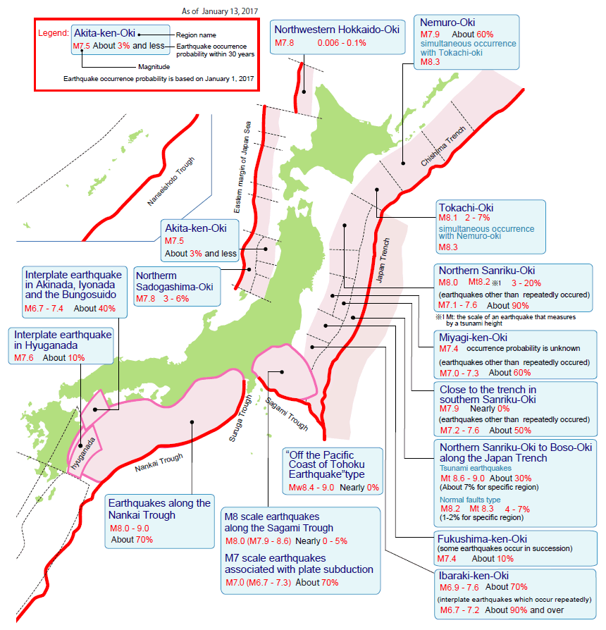
This morning we were awoken by an earthquake of magnitude 7.3, shindou 5- off the coast of Fukushima with some small aftershocks. Our phones immediately gave off tsunami warnings (1-3 meter). Several coastal towns have received evacuation warnings.

This map shows the locations and heights of tsunami waves in cm measured according to the JMA:

Friday, October 28, 2016
News in Japan - October
USA
Other
Watersheds
Lost Up to 22% of Their Forests in 14 Years. Here’s How it Affects Your Water
Supply High erosion deteriorates water quality and reduces reservoir
capacity, increasing the cost of water treatment and the risk of contamination.
High erosion risk is usually linked to erodible soil, intense rainfall, steep
topography and conversion of forest and other natural lands to pasture,
cropland and more.
How
fast will we need to adapt to climate change? Using sea-level rise as a
case study, researchers at Carnegie's Department of Global Ecology have
developed a quantitative model that considers different rates of sea-level
rise, in addition to economic factors, and shows how consideration of rates of
change affect optimal adaptation strategies. If the sea level will rise slowly,
it could still make sense to build near the shoreline, but if the sea level is
going to rise quickly, then a buffer zone along the shoreline might make more
sense. "It is a very different thing to adapt to a sea level that is three
feet higher if you think that sea level will rise no farther after that, than
to adapt to a sea-level rise that is three feet higher with the expectation
that the seas will keep rising," remarked Soheil Shayegh, a former
Carnegie postdoc and lead author of the study.
Reservoirs
play substantial role in global warming The world's reservoirs are an
underappreciated source of greenhouse gases, producing the equivalent of
roughly 1 gigaton of carbon dioxide a year, or 1.3 percent of all greenhouse
gases produced by humans.
Evaluating
forecasting models for predicting rainfall from tropical cyclones more than
50 percent of the deaths associated with hurricanes from 1970 to 2004 were
caused by fresh water flooding. And from 1981 to 2011, hurricane damage
accounted for almost half -- $417.9 billion -- of the total monetary damage
from all weather and climate disasters during that same time period (adjusted
for inflation to 2011 dollars). Current models can forecast both where and how
much rainfall a tropical cyclone will produce up to two days in advance.
However, the forecast's accuracy decreased significantly when the prediction
window increased to five days.
Hurricane
Matthew is just the latest unnatural disaster to strike Haiti At least
1,000 people were killed when Hurricane Matthew battered the Tiburon peninsula
in Haiti last week, destroying houses and displacing tens of thousands. Other
experts describe disasters as “manifestations of unresolved development
problems”. Therefore, disasters are not a natural phenomenon. Humans play a
central role. As a result, a natural hazard such as Hurricane Matthew impacts
each country in its path differently. We know that development, imposed by
external forces that exploit the local labour force is not in the interest of
the marginalised. A failure to respect human rights, local needs, the
environment and human-environment relations simply creates disaster risk.
Scientists
find link between tropical storms and decline of river deltas Lead
researcher Professor Stephen Darby of the University of Southampton said: “Our
study is the first to show the significant role tropical storms play in
delivering sediment to large river deltas.
We show that although human impacts affect the amount of sediment in a
river – cyclonic activity is also a very important contributing factor. These
results are very significant because the Mekong’s sediment load is already
declining as a result of upstream damming and other human impacts such as sand
mining. Understanding the role played by changes in tropical cyclone
climatology gives us a broader knowledge of the threats facing this delta and
others like it around the world.”
Receding
glaciers in Bolivia leave communities at risk A new study published in The
Cryosphere, an European Geosciences Union journal, has found that Bolivian
glaciers shrunk by 43% between 1986 and 2014, and will continue to diminish if
temperatures in the region continue to increase. "On top of that, glacier
recession is leaving lakes that could burst and wash away villages or
infrastructure downstream," says lead-author Simon Cook, a lecturer at the
Manchester Metropolitan University in the UK.
Thursday, October 13, 2016
Pressure and Release (PAR) model, part 3
Our students this year are a diverse group of meteorologists, engineers, government officers, hydrologists, dam operators, infrastructure analysts, and researchers, coming from Brazil, Malawi, Mozambique, Myanmar, Pakistan, Papua New Guinea, Philippines, Timor-Leste and Vietnam. As such we received a great diversity of suggestions during the interactive part of the lecture. For this part, I divided the students in three groups to each work on a different type of flood affecting the Netherlands: oceanic storm surges, river floods, and heavy precipitation.

The goal of the exercise was to develop safe conditions for each type of flood, as integrated in the PAR model. This would allow students to actively familiarize themselves with the PAR model as preparation for their course assignments, stimulate group discussions, and have them consider the cross-cultural transferability of disaster risk reduction measures.
Wednesday, October 12, 2016
Pressure and Release (PAR) model, part 2
To prepare students for their PAR model exercise, I explained briefly about the conditions in the Netherlands and the three types of flood we might face. Below is a selection of the presented slides.
I developed a pressure model for floods in the Netherlands as shown below (click to enlarge). It was up to the students to develop safe conditions to increase the progression of safety, countering a different type of flood in the Netherlands.


Pressure and Release (PAR) model, part 1
Along with now graduated Dr. Nasif Ahsan, I was invited to give a lecture to our new M.Sc. students as part of the course "Basic Concepts of Integrated Flood Risk management (IFRM)". This part of the course centers around the Pressure and Release (PAR) model, as developed by Ben Wisner, Piers Blaikie, Terry Cannon, and Ian Davis in their publication "At Risk: natural hazards, people’s vulnerability and disasters" (Routledge, London & NY, 2004).

The concept behind the PAR model is that disasters occurs when societal vulnerability coincides with (natural) hazards.The only way to reduce risk is reduction of vulnerability, rather than the hazard itself. This concept is explained in the images below.


For the lecture we each focused on how the PAR model could be applied to our home countries, Bangladesh and the Netherlands. I added an interactive component in which the students developed their own version of the PAR model for floods in the Netherlands.

Friday, September 30, 2016
News in Japan - September
Japan
It seemed to miss
Japan altogether before coming back with a vengeance:
USA
Other
How
plant roots sense, react to soil flooding Researchers
have just discovered a mechanism that allows a plant to adjust its water status
and growth according to different soil flooding conditions. The results of this
study describe how roots sense and respond to soil oxygen and potassium levels
jointly, so as to change their water uptake capacity. Aside from their
scientific importance, these findings could make it possible to optimize crop
flood tolerance.
http://aqua-monitor.appspot.com/
Vulnerable people
Floods
severely affect children, young people Research
with flood-affected children reveals serious impacts on well-being but also a
desire to take on a role in flood risk management. Factors impacting on
children's well-being include: loss of valued personal and family possessions,
friendship networks, familiar spaces, education; experience of fear, anxiety,
poverty, isolation, unfairness, destruction, stress, uncertainty, being
ignored/misunderstood; lack of sleep and recreation; deterioration in diet,
space and housing conditions; lack of flood education provision in schools for
children and all staff. The study shows that having an active role in flood
risk management actually helps with children's recovery. Yet current flood and
emergency planning policy either ignores children or positions them as
'vulnerable', rather than treating them as citizens in their own right. The
report proposes children should be given more information before, during and
after flooding because they have a right to know how to prepare, what to expect
and how they can contribute.
Wednesday, August 31, 2016
News in Japan - August
USA
Adaptation to climate risks: Political
affiliation matters. Study takes into account perceptions of New York City
residents after Superstorm Sandy A new study reveals that those who affiliate with the Democratic Party
have different views than those who vote Republican on the following issues:
the likelihood of floods occurring, adopting protection measures, and
expectations of disaster relief from the government. Key findings:
- Democrats' perception of their probability of experiencing flood damage is significantly higher than Republicans'. They are also more likely to expect climate change to increase the flood risk they face in the future.
- Democrats are also more likely to invest in individual flood protection measures.
- Less than half of Democrats and a third of Republicans trust the government to address the flood risk posed in their area of residence.
- 50% more Democrats than Republicans in the study expect to receive federal disaster relief after a major flood.
Hurricanes are worse, but experience, gender and politics determine if you believe it Despite ample evidence that Atlantic hurricanes are getting stronger, research found that people's view of future storm threat is based on their hurricane experience, gender and political affiliation. This could affect how policymakers and scientists communicate the increasing deadliness of hurricanes as a result of climate change.
Other
New meta-analysis shows engineered hard
shorelines are a threat to ecosystems (global) Hardened
shorelines reduce species diversity, abundance. "Biodiversity was 23%
lower along shorelines with seawalls when compared with that of natural
shorelines," observed the authors. Moreover, Gittman and her colleagues
noted that overall organism abundance was 45% lower in seawalled areas. One
potentially encouraging finding was that biological diversity and the abundance
of organisms were not demonstrably altered by other forms of shoreline
hardening, such as riprap and breakwaters. The authors report that "some
shore-protection structures may serve as surrogate habitats for native epibiota
where natural hard substrates, such as oyster reefs and mussel beds, have been
lost to overharvest, erosion, and poor water quality." However, Gittman
and her colleagues caution that such structures may enable invasive species or
have other unintended consequences.
Friday, August 5, 2016
Published paper
The Journal of Disaster Research has published an article by Nasif Ahsan, myself, and others, titled "A Systematic Review of the Factors Affecting the Cyclone Evacuation Decision Process in Bangladesh". It is freely available at the JDR website, after creating a free account.
Abstract
Researchers are investigating a broad spectrum of factors affecting positively and/or negatively the evacuation decision-making process occurring after people at risk receive cyclone warnings and advisories. Previous studies suggest that early warnings themselves do not propagate evacuation processes to be investigated but, rather, that human risk perceptions do so. This in turn encourages the socio-psychological dimensions of risk perception to be evaluated, which must be done within a country’s own cultural context. In applying content analysis here, we review the literature on evacuation decision-making processes during rapid onset hazards, i.e., tropical cyclones, in coastal Bangladesh. We focus on three broad overlapping themes – early warning, risk perception, and evacuation decision-making. Major content-analysis findings suggest that two things – a lack of credibility in early warning messages and an inefficient dissemination process – tend to affect the risk perception of people at risk and are likely to eventually determine the success of evacuation decision-making. Findings also show that different socioeconomic and socio-cultural issues related to risk perception appear to be more influential than formal warning messages in propagating decisions to evacuate during a cyclone. Based on these results, we suggest specific policy recommendations for improving local evacuation efficiency.
Journal ref: Journal of Disaster Research, August 2016, 11(4), 742-753
Received: 31 May 2016
Accepted: 14 July 2016
Released: 1 August 2016
DOI: 10.20965/jdr.2016.p0742
Impact Factor pending
Friday, July 29, 2016
News in Japan - July
Japan
Joso city video and fund raiser (Japanese)
USA
Scientists release recommendations for building land in coastal Louisiana Sediment diversions should be operated on a pulse that mimics the natural flood cycle of the Mississippi River, which includes taking full advantage of winter flood peaks from November through February when the greatest concentration of sediment is available in the river to sustain the coastal wetlands, as well as operating in the spring when sand needed for building land is at its highest. Operations plans should include robust monitoring and flexibility for adjustments based on rapidly changing conditions, such as hurricanes and other events.
Mixed response: Floodwaters return to the Colorado River but can release greenhouse gases Deliberately flooding riverbeds left parched by dams has great potential to restore wetlands but may also have a significant unintended consequence: the release of greenhouse gases. When a large dry riverbed is flooded, these greenhouse gases are released into the water, and presumably to the atmosphere. However, re-wetting the delta may support the growth of native plants, which typically are better able to absorb and store carbon than invasive species, and may offset the carbon dioxide and methane released by flooding.
Netherlands
Other
Mitigating floods with an electronic brain Artificial neural networks (ANNs) are a biologically-inspired method of computing that can receive large amounts of data, find patterns, learn from them and then develop predictions for future events. They have been proposed as a useful tool to process the complex relationships between large amounts of data related to the transformation of rainfall into runoff. This relationship is one of the most difficult hydrological problems faced by water resource managers. Researchers at Universiti Putra Malaysia "taught" an ANN to predict daily runoff for the Bertam River into the Ringlet Reservoir 200 km north of Kuala Lumpur. They collected daily rainfall and stream flow data from the Bertam River catchment area over a ten-year period, from 2003 to 2012, and estimated daily water evaporation using temperature data collected from the nearest station to the reservoir. Seventy percent of this data was input into the model to "train" it while the remaining 30% of the data was used to test the model's accuracy using statistical evaluation measurements. The ANN was developed to map the relationship between rainfall and runoff. The more factors used, the more accurate the results. The ANN was able to predict river stream flow into the reservoir with 76% accuracy.
Thursday, July 7, 2016
Published conference paper: The benefits of cyclones of ecosystem services
The 7th International Conference on Water Resources and Environment Research has published all reviewed extended abstracts, including our contribution on the topic "The Benefits of Cyclones as Ecosystem Services".
You can read the full version here on research gate.
You can read the full version here on research gate.
Thursday, June 30, 2016
News in Japan - June
USA
"Social and environmental cues influence behavior," said Sarah DeYoung, postdoctoral researcher at DRC who was the lead author of that paper and has just accepted a tenure-track position at the University of Georgia. "But we understand, too, the temporal nature of that," Davidson said. "It's not like people make a decision on Day 1 and follow through with that. They see what happens and change their minds, too."
Netherlands
https://twitter.com/Du_Knitter/status/738237664948834304/photo/1 Dutch A74 highway closed due to
flood/mudflow.
Other
Heavy rain in Germany leads to 4 deaths (Dutch) Over 40 people were rescued from life
threatening situations. One of the four victims was a male firefighter. The
weekend before 35 people were struck by lightning.
Thousands of evacuations due to floods in
France (Dutch) Over 5,500
people were evacuated, firefighters responded to 10,500 calls for help, and one
86 year old woman reportedly drowned.
El Nino made a nuisance of itself in 2015
Parts of Philippines may submerge due to global warming
New data set establishes global flood risks more accurately (Dutch)
Parts of Philippines may submerge due to global warming
New data set establishes global flood risks more accurately (Dutch)
Vulnerable people
Revamped labor guidelines to issue sterner warning
against LGBT discrimination (Japan)
News in Japan - June
USA
"Social and environmental cues influence behavior," said Sarah DeYoung, postdoctoral researcher at DRC who was the lead author of that paper and has just accepted a tenure-track position at the University of Georgia. "But we understand, too, the temporal nature of that," Davidson said. "It's not like people make a decision on Day 1 and follow through with that. They see what happens and change their minds, too."
Netherlands
https://twitter.com/Du_Knitter/status/738237664948834304/photo/1 Dutch A74 highway closed due to
flood/mudflow.
Other
Heavy rain in Germany leads to 4 deaths (Dutch) Over 40 people were rescued from life
threatening situations. One of the four victims was a male firefighter. The
weekend before 35 people were struck by lightning.
Thousands of evacuations due to floods in
France (Dutch) Over 5,500
people were evacuated, firefighters responded to 10,500 calls for help, and one
86 year old woman reportedly drowned.
El Nino made a nuisance of itself in 2015
Parts of Philippines may submerge due to global warming
New data set establishes global flood risks more accurately (Dutch)
Parts of Philippines may submerge due to global warming
New data set establishes global flood risks more accurately (Dutch)
Vulnerable people
Revamped labor guidelines to issue sterner warning
against LGBT discrimination (Japan)
Wednesday, June 8, 2016
ICWRER day 3
I presented today, on the final conference day of the International Conference on Water Resources and Environment Research. But first we enjoyed a keynote speech from Mathias Kondolf from the University of California, Berkeley, who talked about "Maintaining and Restoring Sediment Load Downstream of Dams". This included the tedious and costly process of re-sedimentation on the Rhine river, and current geomorphic impacts on the Mekong Delta.


Tuesday, June 7, 2016
ICWRER day 2
The second day of the International Conference on Water Resources and Environment Research in Kyoto featured two keynote speeches. The first, from Prof. Hubert Savenije from the Dutch Delft University of Technology, touched upon drought models and root zone storage. He explained how different drought models led to opposite results for the Netherlands, and a local model often functioned better than a global one. He further set out his theory how most of the traditional ground storage models did not account for root storage correctly. These models assume that plants would use the entire soil depth to grow roots in, when in practice this was not the optimal growth strategy for plants. In fact, especially in moist areas, there is no need for plants to have deep roots as they can already gather enough moisture from the top soil layer, and then invest more in growing above ground.


Monday, June 6, 2016
ICWRER day 1
The International Conference on Water Resources and Environment Research opened on Sunday, June 5th with a welcome icebreaker. The actual conference was opened the next day with a keynote speech from Prof. Eiichi Nakakita from the Kyoto University, who spoke on the SOUSEI project, that ICHARM is also a part of, which has as goal to integrate research activities on climate change and natural hazards.

Another presentation of importance today was given by Guillermo Q. Tabios III, who chaired the topic of Sustainable Water Resources Management (G14). His presentation was titled "Multipurpose, Single High Dam versus Multiple Dam System for Balog-Balog Irrigation Project in the Philippines", and detailed the costs and water usages of several dams in the Philippines.

Subscribe to:
Posts (Atom)