Having visited the GSI twice already, I had yet to experience any information in English. We received two lectures on the activities relating to disasters and a short guided tour, including of course a 3D view of Japan. New maps included an overview of all the stops of the JR line from Ushiku to Tokyo, passing by Nagareyama and showing the channel we visited earlier this month. This time I managed to find GRIPS on the current and old maps of Tokyo, as well as Hibiya park and Tokyo station.
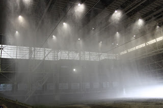
A big highlight at NIED was the ability to make more accurate rainfall predictions than the JMA, as they use ground based radars (including mobile ones). The second impressive feature was visiting the large scale rainfall simulator. Installed in the ceiling of this mobile building are four types of water sprouts, capable of simulating up to 200 mm per hour rainfall, which was of course demonstrated. There will be an open day in April with a typhoon and earthquake simulator as well, so I am eager to return here.


No comments:
Post a Comment