Saturday, October 15, 2011

Trip: Building Research Institute

All Disaster Management Program students were taken on a tour together with the students at the Building Research Institute. First the governmental testing sites were covered. We saw a demonstration of modelling a sand levee breach and we went to the only governmental testing location for the calibration of water speed measuring devices.

After this we visited the Building Research Institute itself, where many earthquake measuring devices were manufactured and tested. Additionally there were testing sites for buildings themselves, such as pressure and pulling devices and tremor plates. We visited the highest testing building in the world, for structures of up to 25 meters in height.


Sunday, September 11, 2011

Earthquake in the Netherlands

Last Thursday evening there was a real earthquake, magnitude 4.5 of the Richter scale, near Nijmegen. It occurred at a 7 kilometer depth, which enabled many people to experience it, but not us. According to nu.nl the earthquake is number 3 of the worst earthquakes in the past 100 years.

One geologist is already spreading doomsday scenario's because current nuclear power plants in Belgium and Germany are 'only' prepared to withstand earthquakes with a magnitude of 6.5.

See these Dutch links for more information: nu; knmi (for an overview of all earthquakes from 1904-2004); powned.


Thursday, September 1, 2011

Survival Japan - Maps

Coming from a land where streetmaps always have North at the top of the map, South at the bottom, East at the right and West to the left, Japanese streetmaps came as quite a surprise. North can be anywhere! More specifically, the direction located behind the map is displayed at the top of the map, the direction behind you when you are facing the map is at the bottom. Easy, right?

It just takes some getting used to. So after figuring out where you want to go from the map near the subway platforms, you often reach another streetmap when you exit the subway on street level. It changed completely. Since you are now facing a different direction, the orientation of the map also changes! Easy, right? Not for me!

It took me one week to figure out it was the same no matter where I went, and even then, being prepared to look at a changed map, it still didn't help. Perhaps with some more practice and turning things around it will get better. The most astonishing thing however, was handout maps. You get a piece of paper that you can turn and hold in any position you like. It would seem logical that in this case, North would be at the top of the paper. Unfortunately, it is not.

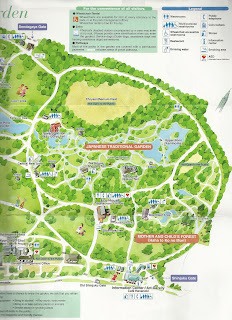
Take for instance the Shinjuku koen map, that shows South at the top, more or less. For this map, it's not a matter of the images and texts fitting better on the paper when it is orientated this way either. So why do this? In any case, this handout map was a good example of what was still to come.


Survival Japan - Earthquakes

My first earthquake: Sunday morning, 10th of July, 10.00 a.m.. I just got up when the hotelroom on the 33rd floor of the Keio Plaza started to sway and creak. And it didn't stop for 2 minutes. Immediately I felt completely safe in the room, but rather dizzy and nauseous. People down on the street outside continued to walk and drive around as if nothing was happening.

Within 5 minutes the website of the Japan Meteorological Agency reported that it had been an earthquake of magnitude 7.1 off the coast of Sendai, and it reached JMA seismic intensity 3 in Tokyo. Only JMA seismic intensity 4 and up can be felt while driving in a car, so it was not too intense.

Given the on average 1500 earthquakes a year in Japan, the average per day is just over 4. But that figure encompasses all the earthquakes in entire Japan. Checking the JMA website for weekly earthquakes has shown 1-4 earthquakes every week in Ibaraki for the month August, scaling from 1 to 5. A recent article in the Yomiri Shimbun reports that the amount of earthquakes, small and big, has increased since the big Tohoku earthquake, especially for the Southern Ibaraki prefecture (which is where I will be living in 1 month).

Coming from a country with 0 earthquakes a year (drilling for gas doesn't really count), this makes it definitely worthwhile to be prepared. I used the guides below to help me prepare. Maybe they can help you too!

Items in my planned survival package:

Food: water and canned food, plastic spoon, medication, first aid kit
Clothes: warm and waterproof, blanket (don't forget shoes!)
Light: flashlight and batteries
Communication: radio and batteries
Travel: maps, pen and paper
Documents: personal information (passport), contact information in the Netherlands and Japan
Other: cash money, plastic bags

Helpful links:
For further preparations the Earthquake Survival Manual from the Tokyo Metropolitan Government is very convenient and detailed.
If you are watching Japanese earthquake news and you have no idea what is going on, try listening to the words on this page to see if you can recognize anything.

Tuesday, August 16, 2011

Information from the Metropolitan Area Outer Underground Discharge Channel

We received a lot of information at the Metropolitan Area Outer Underground Discharge Channel, some of which is posted below.

A Japanese folder with information:

An English folder: "Sairyu no kawa" (PDF, 1.7 mb) filled with technical statistics.

The postcard which served as ID during the tour, and which you could take home afterwards:

Sunday, August 7, 2011

Visit to the Metropolitan Area Outer Underground Discharge Channel

We made our trip to Japan and among the many places we visited was the Metropolitan Area Outer Underground Discharge Channel (首都圏外郭放水路 shutoken gaikaku hōsuiro). It went exactly as described on this blog: http://blog.japantwo.com/2010/06/25/700 but there were a few exceptions.


The Japanese guide was very speedy in her speech and although I knew what was coming and understood the general gist, I was taken aback when she suddenly posed me a question and the whole tour group stared at me, waiting for a reply.... "Wakarimasen...", I had to say, because I really had no idea what this part was about. It was very embarrassing! Luckily we could join a Scotsman and his Japanese wife who was translating for him as the guide went through the '"you will descend 116 steps and you cannot take pictures until you are down at the bottom"-story, which was the part I did understand. In any case it was a good excuse to chat more with other English speaking tourists, and a good encouragement to study more!


The Ryukyukan where the tour starts is filled with moving models and maps, showing how the installation works and which area it affects. There is a special movie theater with walls similar to the underground concrete pillars and sound effects of water dripping, making you experience the discharge channel as if you were already there. The movie itself is mainly about how the discharge channel manages to tame the slightly aggressive 'blue river dragon'. The building also has a wall filled with pictures and signatures of famous people making movies and commercials inside the tunnels.


Given that this tour is free and you get so much information, and the chance to experience the huge, dark and damp underground atmosphere of this hidden mega construction, it is certainly worth a visit.

Saturday, June 11, 2011

G-Cans in Japan - Tokyo Metropolitan Outer Underground Discharge Channel

Coming up first is a holiday to Japan with a visit to the world famous G-Cans! (More information here and here; with more pictures here.) In Japanese this is called the 首都圏外郭放水路 shutoken gaikaku hōsuiro, and it's a massive underground system of interconnecting tunnels and basins for excess water. To walk around inside this structure is going to leave a lasting expression to be sure.